2009 (2X), 2011, 2012, 2013,
2014, 2015, 2016, 2018, 2019,
2021 and 2023.
Walking, hiking and trekking on ANDROS
WALKS
(last update on the 22nd of February 2024)
*** = very beautiful
**** = exceptional
+ Gpx = with Gpx-file
1. Agia Triáda - Zagorá
and back
2. Agia Triáda - Aládou - Sasá - Moní Panachrántou
- Messariá
3.
Agios Nikólaos - Achla and back **** + Gpx
4.
Aïdónia - Ráchi - Agios Ioánnis and back ***
5. Aladinoú - Kouréli - Sasá - Aladinoú
6. Aladinoú - Sasá - Moní Panachrántou - Pétrias - Fállika - Aladinoú ***
7. Alamaniá - Piskopió - Rogó - Ormos Korthíou ***
8. Ano Aprovátou - Ano Pitrofós - Strapouriés
**** + Gpx
9. Chóra ***
10. Chóra - Apíkia - Evrousés
- Strapouriés - Mesathoúri - Ypsiloú- Chóra **** + Gpx
11. Chóra - Apíkia - Pithára -
Chóra ***
12. Chóra - Apíkia - Steniés -
beach Giália - Chóra ***
+ Gpx
13. Chóra - Apíkia -
Katakaléï - Vourkotí and back ****
+ Gpx
14. Chóra - Lámyra - Ménites
and back **** + Gpx
15. Chóra - Lámyra - Ménites - Messariá - Lámyra - Chóra ****
16. Chóra - Lámyra -
Ménites - Messariá - Moní Panachrántou -
Messariá - Lámyra - Chóra ****
+ Gpx
17. Chóra - Lámyra -
Strapouriés - Ano Pitrofós - Ano Aprovátou - Batsí **** + Gpx
18. Chóra - Lámyra - Strapouriés - Ménites - Lámyra
- Chóra ***
20. Chóra - Livádia - Petriás
- Moní Panachrántou and back ***
+ Gpx
21.
Chóra - Sinetí - Dipotámata-valley and back ***
+ Gpx
22. Chóra - Sinetí - Dipotámata-valley - Kochílou - Ormos Korthíou ****
+ Gpx
23. Chóra - Vrachnoú - Pétrias - Fállika - Aladinoú - Vakóni ****
24. Fállika - Moní Panachrántou and back ***
25. Gávrio - tower of Agios Pétros - Gávrio N
26. Messariá - Ménites - Lámyra - Chóra ***
27. Messariá - Ménites
and back *** + Gpx
28. Ormos Korthíou - Kochýlou -
Epáno Kástro and back ****
+ Gpx
29. Ormos Korthíou - Panagía and back
30. Ormos Korthíou - Tis Griás to Pídima and back
31. Ormos Korthíou - Rogó - Lardiá - Mésa Vouní - Exo Vouní Kochýlou *** + Gpx
32. Ormos Korthíou - Rogó - Lardiá - Mésa Vouní and back **** + Gpx
33. Paleópolis - Agia Eleoúsa - beach of Paleópolis
34. Piskopió - Alamaniá and back
35. Píso Meriá - Profítis Ilías - Stavrós and back ***
36. Strapouriés - Ano Pitrofós
- Paleópolis **** + Gpx
37. Vakóni - Aladinoú - Fállika -
Pétrias - Livádia - Chóra **** + Gpx
38. Vakóni - Aladinoú - Fállika - Pétrias - Vrachnoú - Chóra **** + Gpx
39. Vourkotí - monastery of Agios Nikólaos - Apíkia - Chóra ***
40. Vourkotí - Profítis Ilías - Agii Saránta and back ***
41. Vourkotí - Profítis Ilías - Arni - Katákilos - Káto Katákilos - Batsí
**** + Gpx
Andros
is the most northern island of the Cycladic isles. The islands of Kéa, Kýthnos,
Sérifos and Sífnos can be seen as a natural continuation in the sea of
the peninsula of Attika; in the same way, the nearby islands of Andros, Tínos
and Mýkonos can be seen as the foothills of the mountain ridge of the
island of Evia (Euboia). Andros is separated from Evia by a narrow strait
(Kafiréa or Cavo d' Oro), but the strait (or ‘stenó’) between Andros
and Tínos is even narrower. Andros (385 km²) is the second biggest
island of the Cyclades, after Náxos (448 km²), but before Páros (195
km²) and Tinos (195 km²).
Andros is mountainous and it is criss-crossed with a number of mountain ridges. All of these ridges run parallel to one another from southwest to northeast. Between the ridges there are deep valleys and sometimes steep gorges. The highest summits are the Kouvára (with the Profítis Ilías at 997 m) and the Pétalo (990 m), in the centre of the island, between the towns of Ano Aprovátou and Vourkotí. Because of this relief the north-south connections on the island are rather difficult. Except for the main coastal road, most of the roads thus run into the valleys, from the southwest of the island to the northeast.
Andros is a unique
island for a number of different reasons. First of all, in comparison with
many of the other Cycladic isles, there is a lot of water – and this
thanks to the relative high amount of rainfall and the multitude of
sources. As a result, some of the valleys are remarkably green. Especially
the pine tree dominates the landscape (for instance in the neighbourhood
of Ménites). There are also lots of remnants of watermills in the valleys
of the Dipotámata (between the towns of Exo Vouní and Sinetí), in the
valley of the Mégalo Révma (in the north), etc.
The second
remarkable characteristic is the architecture of some of the villages,
which is not really Cycladic. Andros is a very wealthy island and this is
partly the result of generations of ship owners. The villages of Chóra and
Steniés are therefore striking because of the large and wealthy houses.
The red roofs resemble the Italian cities and also some Greek islands such
as the island of Sími near Rhódos.
Striking is also the large amount of villages on this island – about
sixty. Only on the
slopes of the large valley of the Megálos Potamós, which flows into the
sea near Chóra, you can count about twenty villages. Usually, these
villages do not really have a centre – they are dispersed midst the
bushes and trees and this makes it sometimes very difficult to orient.
With regard to its
touristy reputation, Andros is not really well-known among foreigners. On
the other hand, though, the island is a favourite destination for people
from Athens. Situated at a distance of only 2-3 hours from their busy
city, many of them have a country house at Andros.
Gávrio, the small harbour on the west coast, is very quiet, except in
summer. There
are only a couple of restaurants and cafés – and a very pretty camping.
Quite strange about Andros as well, is that it can only be reached from
the harbour of Rafína; from Rafina there are frequent connections with Tínos
and Mýkonos, via Andros – sometimes even further on with the islands of
Páros and Náxos. Connecting with the other Cycladic isles is rather
difficult – there is only the
Artemis: this boat guarantees,
on Wednesday, a connection with Sýros
and Sérifos/Sífnos/Kímolos/Mílos.
The only spot on the island of Andros that is really touristically
exploited is the coastal town of Batsí: there is a nice beach, but the harbour is small and not very
picturesque. A few modern hotels are a blot on the coastline and in the
town itself there are even three pizzerias and two Illy-cafés close to
each other. This is the place to be for tourists only looking for the
beach and some nightlife.
Chóra (sometimes
also called Andros), on the east side of the island, is really a whole
world of difference. This town is very picturesque, situated on a
protruding rock, between the beaches of Nimborió and Parapórti. The
long, central street, with marble pavement is a pedestrian area. It runs between beautiful, large houses and along a couple of pleasant
squares with peaceful restaurants and many zacharoplastía (pastry shops).
This street goes all the way to the summit of the protruding rock, with
remnants of the Venetian kástro, established in 1207 by Marino Dandolo.
Especially in spring and autumn Chóra is a haven of peace; it is mostly
frequented by Greeks and it is really a wonderful place to hang out.
When looking at the other small villages, it is difficult to make a
choice. Very nice is
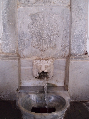
the green village of Ménites, with marvellous wells decorated with lion
heads; there is Apíkia with the famous Sáriza-well and the small
waterfall of Pithára; there is the beautiful village of Sinetí, at the
end of the Dipotámata-gorge, remarkable because of its water mills; there
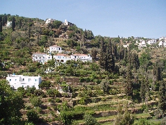
is also the agrarian and highly situated village of Vourkotí, with its
terraces, etcetera.
On an archaeological level, there are two interesting sites at Andros. The
archaeological site of Zagorá was situated on a plateau, protected on
three sides in a natural manner. In the geometrical period (10th
– 8th centuries BC), a prosperous settlement was established
on this spot. When looking at the remnants, especially the 110-metres-long
defensive wall is remarkable – this wall used to be 7 metres high!
In the plain underneath the current day village of Paleópolis, there is
also an archaeological site. Over here, remnants were found of the former
capital of Andros, founded in the 6th – 7th
centuries BC. Part of it disappeared in the sea during the heavy
earthquake in the 4th century AD. There are remnants of
an agora and a defensive wall. When
looking into the water – especially when standing on an elevation -, you
can clearly see the remainders of a kind of a breakwater. The remnants of
the geometric period from Zagorá and the findings from Paleópolis –
with especially the beautiful statue of Hermes, which is a copy from the 1st
century BC of a bronze statue made by Praxiteles – can be found in the
beautiful Archaeological Museum of Chóra. There is also a Museum of
Contemporary Art, containing mainly Greek artists; amongst others there
are many sculptures from the Andriotic artist Michális Tómbros. In
summer this museum is also well-known because of its international
exhibitions, for instance of Picasso, Matisse, Klee, Rodin, Moore, etc.
Although the largest part of the coast is obviously rocky, there are also some really beautiful beaches on Andros, mainly on the west coast in the neighbourhood of Gávrio and Batsí. Nevertheless, the most pleasant and also the most quiet beaches are the ones on the east and the southeast coasts. I am referring here to the beaches to the north and the south of Chóra: Nimborió (very pleasant for children) and Parapórti, the beaches of Giália and of Kórthi and the lonely beaches of Achla, Léfka and Agios Ioánnis – these beaches can only be reached on foot!
But of course, the
most interesting aspect of Andros is the opportunity to make many
wonderful hikes. Especially in the south-eastern part of the island there
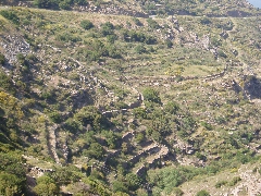
is an entire network of trails. Many of them are marvellously paved (real
'kalderimi's'), often running between beautiful walls. These walls are
built in a typical Andriotic fashion, alternating between small rocks and
large, vertical plates (see "The paths and walls of Andros").
Even more striking is that, over the last couple of years, an almost
unique effort has been undertaken - taking Cycladic standards into
consideration -, to signpost a number of these trails. This has not always
been done in a consequent and perfect manner, but these signs are still a
great help to the inexperienced hiker. An advantage is also that almost
all of the hikes depart from or arrive in Chóra – which turns this town
into an ideal operating base for the hiker on Andros.
In addition, a lot of material can be found on Andros and its hikes: besides the websites (see "Links Andros"), there is the very beautiful publication "Odiporikó stin Andro" ("Hiking on Andros"). According to my knowledge, this publication only exists in Greek and it is quite difficult to find. This book contains beautiful pictures and the descriptions of about twelve hiking trajectories. In the bookshops and souvenir shops of Chóra you can also find the marvellous CD-rom “Sta Paliá Patímata - On the old trails" by Vasílis and Mína Kokótis. This CD-rom is in Greek and English, it contains lots of pictures and background information and it also gives you the detailed and very personal description of twelve (mainly the same) hikes.
In 2024, a beautifully published and very handy booklet was published with
15 short circular walks: DISCOVER ANDROS in LOW
GEAR is by GERARD KLEYNE, a volunteer
at Andros Routes for many years.
In this book you will find 15 short and relatively easy circular walks.
The walks are between one and a half and four hours walking time.
Often with a nice resting place or a quiet beach where you can swim.
With (almost) every walk you will find a short YouTube video so that you can
see in advance what you will encounter.
Furthermore, a gpx file and a link to Google Maps are included, so that you
can see where you are on your mobile phone.
Finally, a lot of information is described about, for example, the history
of the things you encounter along the way, with a lot of opportunity for
deepening through a number of QR codes that provide much more information.
For sale from the author at
androslight@solcon.nl for € 18,95.
In August 2014 was published a very good and complete hiking map by
Andros Routes and Anávasi: it gives also the new hikes, as the hike [18],
and also some walks in the north-western part of the island - see also
http://www.androsroutes.gr/en/
An enthusiast group of volunteers takes care of the way marking and the
maintenance of the paths. They published also an interesting walking
guide "Hiking on Andros".
1. Chóra - Ipsiloú - Lámyra - Ménites - Messariá - Moní Panachrántou (nicely signposted by means of the number 1)
2. Ano Aprovátou - Pitrofós - Strapouriés - Lámyra - Chóra (very well signposted by means of the number 9 till Strapouriés, and later by [10] and [1])
3. Chóra - Sinetí - Dipotámata-vallei - Kochílou - Kórthi (fairly well signposted by means of the number 3)
4. Chóra - Apíkia - Vourkotí (fairly well signposted by means of the number 2)
5. Agios Nikólaos - Achla and back (signposted by means of the number 6)
6. Vourkotí - Profítis Ilías - Agii Saránta or Vourkotí - Arni - Katákilos - Batsí (signposted by means of the number 12).
Since January the 1st 2004
you are visitor n°

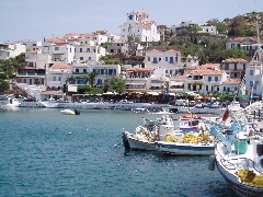
The little port of Gávrio
The seaside resort of
Batsí
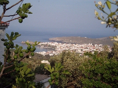
Panoramic view on Chóra
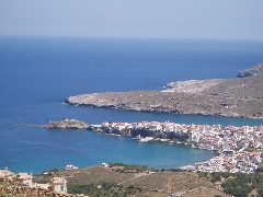
The beautiful position of Chóra
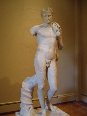
The Hermes in the Archeological Museum of Chóra
The Sáriza-well in Apíkia
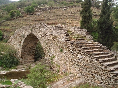
The Stichioméni-bridge near Messariá
The wells in Ménites
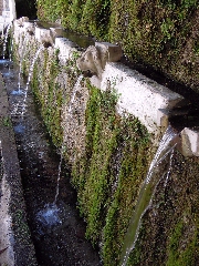
One of the most green spots in Andros: the valley of Ménites
The monopáti in the Dipotámata-valley

The little Pithára-waterfall in Apíkia
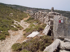
The signposted monopáti to Vourkotí

The typical walls of Andros
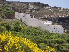
The fortified monastery of Panachrántou
Enjoy life on Andros...