Ano Meria - Livadaki - Angali - Chora |
||
| Evaluation:
This is the longest and probably also the most beautiful hike you can
make on the island of Folégandros. You walk on a couple of marvellous
monopátia and along the way you can swim on the beaches of Livadáki
and Angáli. Obviously, this hike deserves an evaluation of ***. Estimated time:
The hike all the way back to Chóra takes more than three hours of
actual hiking time – some pauses and stops to swim on one of the
beaches will turn this hike into a full day of about 6-7 hours.
Therefore, you should definitely take the bus from Chóra at about 10am.
On the way back you can decide to return by bus from the road above Angáli
– this shortens the hike by 50 minutes, but you should not forget to
write down the bus schedule before departing. Route
description:
You can take the bus at the southern side of Chóra. After a
20-minutes-ride you get off the bus at the last stop in Ano Meriá –
this is Merovígli (the café over there is called To Iliovasílema =
the sunset). You follow the asphalt road straight ahead for another 5
minutes and you then take a left (there is a signpost to Livadáki).
The monopati to the chapel of Agi Anargiri. After about 7 minutes, at the foot of a small hill, you can get to
the chapel via a concrete staircase. From this chapel you have a beautiful view on the beach and the
lighthouse. After this short detour you return to the main trail
and you continue past the hill top. The
trail curves further to the left, in the right direction, with a view on
the lighthouse. On the right you also get a nice view on Mílos and Kímolos.
Another 5 minutes later the trail gets vaguer, while you descend
on a rocky slope. You
keep more to the right, you walk in between some cairns and underneath
the slope you go left sharply – the trail is clearer again. After
another 2 minutes you get to a stony slope which leads to a trail; you
follow this trail to the right sharply (there are some worn away green
arrows).
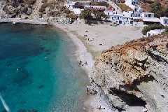
The monopati that descends to Livadaki. The monopáti now clearly runs in between walls; after 5 minutes you walk on the left-hand side of ruins and further down you go left. The following descent runs beautifully in between walls, straight towards your aim Livadáki. After a couple of minutes the trail gets narrower again and it continues on some rocky terrain in between – at least for Folégandros – a lot of green. The lighthouse appears again in front of you and you descend on the rocky trail – the sea is still deep down on your right-hand side. After descending for 5 minutes you are down, on the marvellous little beach with sand and white pebbles. At the end of the valley you can distinguish the chapel of Agi Anárgiri high up – on the spot where you were standing a couple of minutes ago.
The little bay of Livadaki. You can go for a
swim before continuing your trip: some 20-30 metres away from the water
you have to go up a steep slope to follow the opposite side of the bay.
You climb up an obvious trail until you see the lighthouse in front of
you again, after some 10 minutes. Guided by cairns you go down again.
However, as soon as you get to a low wall, where you cannot continue,
you should stop going down – in contrast with what Marc Dubin seems to
suggest. With some difficulties it is still possible to reach the
lighthouse in about 5 minutes, but from there onwards the trail is
almost impossible to find – or you should return to this point. The red-brownish monopáti gradually climbs up the slope of the hill and basically all the time there is a low wall on your right-hand side. After 12 minutes you can clearly see the trail continuing on the next slope in front of you. Halfway this second slope the wall curves to the right and you continue to go up on the left until you reach the next pass. From here you have a marvellous sight on Chóra and on the coast with the bay of Angáli – this is a great spot to have a picnic. A couple of minutes further you get to a rocky plateau and from there you descend towards the left, on a beautiful trail in between walls and in the direction of some ruins. At the end of the trail, near some olive trees, you arrive at a stony three-forked-junction, with the ruins on the right. The trail on the left leads to Stavrós (see the hike Chora - Ano Meriá). You take a right, in the direction of the bay.
|
The
fairly broad trail descends rather steeply in between two low walls, in
the direction of the bay and with a view on the terraces above the bay
of Agios Nikólaos. Further down the trail runs horizontally
again, but it is more difficult to follow because of the rocky terrain. You
should walk in the direction of the bay of Angáli and when you have a
good look you can see the trail continuing on the next slope. Very far
away in front of you, you can distinguish the idyllic little church of
Christós, where you will arrive later on. Also some cairns and green
dots help you to find the right way. On the left of a number of olive
trees you reach the lowest point and then you go up again for a little
while. A little further you keep to the left and you do NOT follow the
trail between walls that goes to the right. The next descent - again
between walls - is really steep; it continues in between the cliff and
the wall, towards the bay of Agios Nikólaos. In front of you there is a
remarkable hill top with a ruin on top of it. In this way you
reach the valley of Agios Nikólaos, some 20 minutes past the junction
and about 45 minutes away from the lighthouse. [At this point you
could descend to the right, towards the beach; thereafter you follow the
trail along the sea till the beach of Angáli.] You go straight
ahead on the rocky monopáti in between walls; at first you walk on a
stony slope and then on a beautiful flat stretch. At the end you get to
a low barred gate and you just have to step over it. On the left there
is another low barred gate and thereafter you just continue. The
beautiful trail curves to the left gradually and after about 7 minutes
you can see a ruin and the “famous” palm tree in front of you –
“famous” because Marc Rubin uses it as a beacon. A little further
there is a path coming from the left – it comes from Agios Pandeleimon
in Ano Meriá (see the route no. 3 with Marc Rubin). You go all the way
to the ruin and the palm tree. From here it only takes about 10 minutes
to descend to the valley, which leads to Angáli – the trail is
sometimes steep and sometimes it descends gradually. On
the way you pass some olive trees, which is rather unusual on Folégandros.
You thus get to the concrete road, on the left-hand side of a large cistern. [At this point you
can shorten the hike by taking the concrete road going up on the left;
on the large asphalt road you can then wait for the bus.
The bay of Angali. After some rest on
the beach you walk to the other side and over there you take the
concrete slope past the first house starting from the beach. In this way
you walk in eastern direction towards the beach of Firá. An obvious
path zigzags up and down between the rocks; after some 7 minutes, past a
small rocky beach, you have to watch out and keep to the left – you
should not start to climb on the overhanging rocks. About 10 minutes
later you arrive on the beach of Firá. On the left-hand
side of the small house at the far end of the beach you find the
beginning of a rocky trail – there is even a red dot. Almost
immediately you can distinguish your next aim, high up, and not too far
away in front of you: the chapel of Christós. After some 2 minutes you
get to a law wall; on the opposite side of the field in front of you
there is a small building. You should climb over the low wall and walk
along the edge of the terrace to the right-hand side of the little
house. Behind the house there is another wall with a barred gate on top of it and a red dot. You
should climb over the fence and meander up the slope – you go in the
direction of the highest green spot halfway the chapel (there are a
couple of red dots to show you which way to go). Behind the bushes you
then even find a trail: at first the trail is a rocky trench, later on
it becomes a gravel path or a rocky trail – until you finally reach
the chapel. This is a wonderful spot, with a great view on the
north-west, with the bays of Firá and Angáli and the rest of the coast.
The monopati just after the chapel of Christos. The sometimes
beautifully tiled trail continues; after 2 minutes, with the three mills
far away in front of you, there is a sharp bend to the right. The
following stretch is a marvellous kalderími, unique on the island of
Folégandros! Some 5 minutes past the chapel the trail gets rockier,
then there is a gravel path, and then again a nicely tiled stretch.
After 15 minutes, this beautiful monopáti gets to the asphalt road, on
the right-hand side of the three windmills and immediately before the
little modern church with a kind of protruding balcony.
You follow the
road for about 350 metres, you describe a bend to the left and
thereafter (at a traffic sign) you take a left on the gravel road that
goes down. After some minutes, at a bend to the left, you go straight ahead on the monopáti. At a three-forked-junction before the last climb you go straight ahead. About 15 minutes later you arrive high up in the town of Chóra, on the first square at the side of the town hall. To
get the printer-friendly version |
|