Apíranthos - Fanári - Kalóxylos - Chalkí |
||
| Evaluation:
This hike starts in the beautiful village of Apíranthos, it goes to the
summit of the Fanári and it continues through an impressive landscape,
but then it turns to the left towards Kalóxylos and Chalkí. Because of the marvellous panoramic view from this
883-metres-high top and because of the wonderful rock landscapes, this
hike deserves an evaluation of ***. In addition, it is a hike easy to
follow, because it is mostly clearly indicated by means of red dots and
stripes
and, during the last part, by means of trail markers [4]. [Update by Raymond on September 28th 2011 and April 23rd 2012.] Estimated time: It takes about 40 minutes (AWT) to hike to the top of the Fanári-mountain, then one hour to the bifurcation of the path to Moní and finally 45 minutes to reach Chalkí. This makes for a total of 2h25 of actual hiking time, which means, in reality, that you should devote about four-five hours to this hike. From Chóra you can catch the bus at 9.30am; you will then arrive in Apíranthos at 10.45am. Taking a fairly long break on top of the mountain and having a picnic somewhere on the way down, means that you can perhaps make it back to Chalkí before the 4h45 bus passes. Eventually, you will have to return by taxi to Chóra... Route
description:
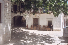
Do not get off at the first bus stops in Apíranthos, but wait until the
bus reaches the furthest part of the village, after having described a
large bend. On the left you will see the church Kímissis tis Theotókou
and on your right-hand side there is a large war monument. From this bus
stop you enter the village, where you can first wander around for about
one hour. You first get to a
rectangular square with the shop of "The Aperinthian women’s
association" (where they sell all kinds of different textile), with
some fancy bars and with the workshop "Apiranthos Art". The
square leads to a beautiful street, paved with marble tiles: to the left
there is the café Samarádiko with a great outdoor terrace; you also
pass the tiny little church of Agios Sardónis. A little further down
you get to the archaeological museum that was established by Michaïl
Bardáni: to be seen in this museum are a lot of small Cycladic statues,
a clay vase from the 3rd millennium BC, a geometric tripodos
from the 8th century, some prehistoric stone tools, bronze
arrowheads, etc.
The platía of Apíranthos. You then reach a
small platía with beautiful houses from 1846 and 1897. Above these
houses you find the folk museum, consisting of three rooms of a not too
old house: in the living room, the kitchen and the bedroom you can see
all kinds of traditional objects and tools. If you want to, you can then
continue to walk
in the
street
for a little while, whereupon you should
return to your point of departure. If you follow the asphalt road
further to the left for a short while, you can also pop into the museums
of natural sciences and geology
(0h00)
You begin this walk on the square, opposite the church of Kímissi tis
Theotókou (so to the right, if you come from the asphalt road), and you
thus take the marble staircase.
After 42 steps you go RIGHT - with a kamára (or archway) on the left
side - and then you take a left (2 X red mark).
After another 73 steps, you follow a flat street, you turn right and
further you go to the left, near a power pole.
A little later, you turn right, then you go
straight; after a right turn, there is again a flat stretch and finally,
you go up and to the left again.
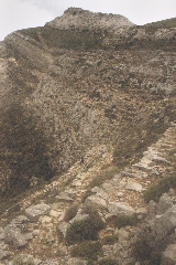
Above Apíranthos, the little church of Agia Paraskeví. You follow across another small concrete road, which rises to the right of the ruins of a mill; the road turns right until you pass a large cistern after some 200 metres. At this point the path bends to the left sharply and it goes up (note the red arrows and dot). A little later, you go right through a breach in a wall. Later, the trail winds and describes 4 times turns right and left. The retaining walls of the monopáti are still clearly visible, but also the red dots are convenient. The path goes up fairly steeply and behind you, you can see that Apíranthos is quite extensive – it also appears to consist of two parts. Beyond the village, towards the south east, you have a great view on the island of Donoússa (on the far left), the island of Amorgós and behind the hill the other small islands or “eremonisiá” (the little islands between Náxos and Amorgós).
Panoramic view over Apíranthos. (0h17) After climbing up steeply for about six minutes you go through another breach in an wall; the trail then continues in between walls. You now walk again on a marvellous stone monopáti, that climbs gently on the almost white slope of the Fanári - further, there are also beautiful steps, then you come again between quite abundant vegetation (two cairns).
Het pad naar de Fanári.
De top van de Fanári. (0h24) A little under ten minutes after the breach, you get to a clear junction: a red arrow directs you to the right sharply, at an altitude of 750 metres. Further on you arrive at a gravel road, which you follow to the right. Two-three minutes later though, you arrive at a sort of pass between the top of the Fanari and a lower summit on your right. (0h30) You take the path that goes up to the left towards the wall and the chapel on the top of the Fanári. This is a beautiful climb, the last minutes on a staircase with 70 heavy steps. On the right, on the lowest summit, you find the small church, with a picnic table; the left-hand top is another ten metres higher. (0h39) Over here you have a great panoramic view: in the Tragéa-valley you can see the villages of Damariónas, Chalkí and Moní. Beyond you can discern the bay of Náxos, with also the islands of Páros, Syros, Tinos and Mykonos. On the other side there is the bay of Mutsúna, with beyond the islands of Donoússa, Amorgós and Koufoníssi all the way to the right.[On April 23, 2012, the view was particularly clear and you could see even more islands: - To the east, you could see, from the left to the right: Ios - Sikinos and the monastery - the elongated island of Folégandros - the group with Polýaigos and Kímolos with behind it Mílos - the island of Páros, very close, with to the left a tip of Antíparos – to the left of Páros, you could see Sífnos, and to the right Sérifos and the vague silhouettes of Kýthnos and Kéa – then Syros, rather close, and more to the right Andros and Tínos, very clear - and rightmost Rhínia and Dílos with Mýkonos, hidden behind the Kóronos - To the west, you could see: Ikaría (behind the mills) and the distant island of Samos (!) - some islands off the coast of Turkey – Donoússa, very close, with the two Makáres islets – the long island of Amorgós with behind it Astypálea - Kéros with in front of it Koufoníssi – to the right Anáfi and then Santoríni, hidden behind the highest peak of the Fanári.]
(0h39) It
takes about ten minutes to descend to the gravel road, which you follow
to the right. You
continue on this road for a little under ten minutes. After
two minutes you pass the trail, which, just now, you followed on the way
up. This time you go straight though, since the path going down will
also get to this gravel road later on. You thus reach a windy
pass again, where the view on the valley in front of you is great. You
continue to go down in the direction of a rocky hill, with two large
pastures, some walls and stables – at the bottom you can clearly
distinguish the staircase-trail. After altogether ten minutes on the gravel road
you take a path going to the right, next to the wall and in a bend –
there is also a cairn, the village of Filóti seems really nearby... You
follow this trail which runs on the right hand side of the wall (note
the red arrow). |
(0h58) Some minutes later you get to a wonderful descent, on a meandering
rocky trail and amidst an impressive landscape. On the right you see the steep cliff of the Fanári, in front of you
there is the marvellous valley with the villages of Moní and Chalkí (invisible
on the left). At first the landscape is very rocky, later on you get to
fields with olive trees. This might be a good spot to have a picnic: if
you are lucky you can even see eagles circling high up in the air. You
can also try to figure out the details of the landscape in front of you:
on the left-hand side of Moní you can distinguish Drosianí; on the
right of Rachídi you can discern the basilica of Agios Isidóros; and deep underneath you
can see the trail in between the walls you will follow later on.
The monopáti that meanders downhill from the Fanári-mountain. Next, you get to
another great descent on a meandering trail; you go down steeply in this
grand landscape! After going down for about fifteen minutes, guided by
red dots and arrows, you get against a wall. You take a right for a
short while and you then go left in between the walls. You walk
over a large, rocky stretch, where water might be flowing sometimes. After some four minutes you keep to the right again and you thus get to a
real bed of a river, in between oleanders. (1h25)
You continue to
follow this bed, strewn with large rocks, for about 200 metres; you stay
on the right hand side of some fields with lots of “machaires”-flowers
(machairi = knife). At the point where the bed narrows, you go up
towards the right on a fairly rocky terrain (there is also a red arrow).
A little further down you take a left again in between walls (another
red arrow) – this is the rocky terrain you saw from high up, some
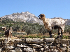
minutes ago. You now get to a pleasant earth trail, which runs between stables and flocks of goat; above the valley with olive trees this trail describes a large bend to the left. Some seven minutes later you reach a couple of small fields, but the red dots (even on trees) do a good job in showing you the right way.
Un regard en arrière sur la terrasse avec les oliviers, juste avant de quitter la promenade vers Moní. After ten minutes all together you get to a cart track or a road, that comes from the right. (1h35) You follow this track STRAIGHT AHEAD.[The walk to Moní - see the hike Apíranthos-Fanári Moní – goes up here to the right (red and red arrows).] You soon reach a rather clear trail that gently descends in zigzags, with on the left a beautiful view over the valley with thousands of olive trees. After about 4 minutes, you arrive at a clearing, with oak trees and mangers: you go to the far left and to the left side of a huge oak; here, you can go down to a small dirt road that comes here to a dead end. (1h40) You follow this road to the right of course: this sandy road descends pretty quickly and after about 4 minutes, there is a bend where a path joins you from the right. You veer left and further, in a curve to the right, the road becomes concrete. Shortly after, you veer left again - the dirt path that you see on the right, comes from Moní (road sign). There is a [4] - you are indeed on the path of the walk from Moní to Chalkí. (1h47) You continue to go down, but a little further, in a bend and 10 m before the concrete comes to an end - you take a trail off the left in between low walls (sign and red dot). You continue for about five minutes (after one minute you should keep to the left) on a sometimes overgrown path. Once in a while, the trail goes slightly down, but all the way it runs above a small though beautiful valley. To the left, you can enjoy a beautiful view on the mountain range with the Fanari, and further on you can admire the entire valley full of olive trees.
Looking to the left on the path from Moní to Kalóxylos. At the end of this
trajectory you go straight ahead again, without paying attention to the
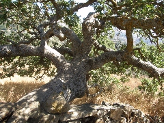
rocky trail that goes up on the right. (1h54) You pass under beautiful, large oak trees - some are really a work of art - and you now continue on a very wide rocky track descending between walls, with a magnificent view over the valley, with Chalkí and Filóti.
Splendid trees...! The path narrows and in
this way you come under a large Mediterranean oak and at a gravel road.
This road winds down to the left, until you
reach a row of maples next to the water; you cross the river bed
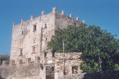
and you continue on a dirt road (sign). (2h15) Approximately 80 meters BEFORE you would reach the main road, you get to a curve, where you continue straight ahead on a broad path that bends to the left and that crosses the asphalt road. On the opposite side, you continue on a concrete little road – a little further you see the (closed) tower of Markopolíti, and you just keep walking on this small road. Just before the asphalt road you take a paved street off the LEFT (sign to Chalkí) and you thus pass the Pýrgos Grazía: above the entrance you see the coat of arms of the famous Venetian family Barozzi.
The impressive Pýrgos Grazia in Chalkí.
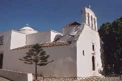
The tower is now restored and paint in white. A little further
you get to your point of departure, next to the Panagía-church. (2h23) The Panagia I Evangelistria in Chalkí.
To
get the printer-friendly version |
|