Apíranthos - Fanári and back |
|||
|
Evaluation:
This short walk describes the way out and back
between the beautiful village of Apíranthos and the summit of mount
Fanári.
Given the wonderful panorama at the summit of 883 meters, this walk gets
***.
[You first get to a rectangular square with the shop of "The
Aperinthian women’s association" (where they sell all kinds of different
textile), with some fancy bars and with the workshop "Apiranthos Art".
The square leads to a beautiful street, paved with marble tiles: to the
left there is the café Samarádiko with a great outdoor terrace; you also
pass the tiny little church of Agios Sardónis. A little further down you
get to the archaeological museum that was established by Michaïl Bardáni:
to be seen in this museum are a lot of small Cycladic statues, a clay
vase from the 3rd millennium BC, a geometric tripodos from
the 8th century BC, some prehistoric stone tools, bronze
arrowheads, etc.
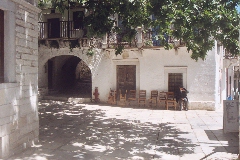
The platía of Apíranthos.
You then reach a small platía with beautiful houses from 1846 and 1897.
Above these houses you find the folk museum, consisting of three rooms
of a not too old house: in the living room, the kitchen and the bedroom
you can see all kinds of traditional objects and tools. If you want to,
you can then continue to walk in the street for a little while,
whereupon you should return to your point of departure.]
(0h00) You begin this walk on the square, opposite the church of Kímissi tis Theotókou (so to the right, if you come from the asphalt road), and you thus take the marble staircase (hiking sign Fanári 30' / Moní 1h50 + [8]).
The marble staircase in Apíranthos, where hike [8] begins. After 42 steps you go RIGHT - with a kamára (or archway) on the left side - and then you take a left (2 X red mark). After some steps and a flat stretch, you meander left through a kamára, then right, and at the end you take again a left and a right. Then you go up again on steps (red dot), you veer to the left and after a flat stretch you finally go up and reach a small concrete road. (0h05) You are here in the northwest part of the village, with on the left the church of Agia Paraskeví with its white dome.
In the upper part of Apíranthos, the little church of Agia Paraskeví.
You follow across another small concrete road ([8] on a pole), which
rises to the right of the ruins of a mill; the road turns right until
you
pass a large cistern after some 200 metres.
The hiking sign for the walks [8], high above Apíranthos.
[The other branch of walk [8] continues to follow the little road - see
the hike Apíranthos - Sífones - Stavrós - Keramotí.] You thus take a sharp left (red dots), but a little later, you go up to the right, through a breach in a wall. You pass through a gate in reinforcing steel (red dot) and later, the trail winds up and describes 4 times double turns to the right and to the left. The retaining walls of the monopáti are still visible, but the red dots are also very useful. The climb is steep and behind you, you can see that Apíranthos is quite large and consists basically of two parts. Beyond the village, towards the south-east, you enjoy a beautiful view over Donoússa (left) , Amorgós and behind the hill over the other eremonisiá (the small islands between Náxos and Amorgós).
Panoramic view over Apíranthos. (0h16) After a steep climb of 2-3 minutes, you again go through a breach in a wall, and the trail then continues for 3 minutes on the green slope. Later on, the beautiful stone path rises slightly on the almost white slope of the Fanári - further, there are also beautiful steps, then you come again in the midst of a quite abundant vegetation (two cairns). |
The path to the Fanári.
The summit of the Fanári.
(0h26) Some 10 minutes after
the breach, you get to a gravel road that you follow to the right
(cairns), but after 4 minutes you arrive at a sort of pass between the
Fanári and a lower summit on your right.
Over here you have a great panoramic view: in the Tragéa-valley you can
see the villages of Damariónas, Chalkí and Moní. Beyond you can discern
the bay of Náxos, with also the islands of Páros, Sýros, Tínos and
Mýkonos. On the other side there is the bay of Mutsúna, with beyond the
islands of Donoússa, Amorgós and Koufoníssi all the way to the right. 

On top of the Fanári.
(0h38) For the way back, you
descend about 10 minutes until you reach the gravel road that you follow
to the right. You follow this road 4 minutes, then you can take the
side-path to the left, next to the cairns [8].
(0h50)
The rest of the way is very easy and you continue smoothly, with a
beautiful view over Apíranthos and Amorgós.
In order to get the
printer-friendly version |
||