|
Chalkí - Apáno Kástro - Potamiá - Agios Mámas - Káto Potamiá |
||
|
Evaluation:
This
is one out of
the hikes running along the beautiful valley of Potamiá (see e.g.
Mélanes – Koúroi – Potamiá – Agios Mámas or Mélanes
- Koúroi
– Potamiá - Chalkí). The
landscape next to Apáno Kástro is truly impressive, the green valley along the
three villages of Potamiá is marvellous, especially in Spring time; in addition,
the spot surrounding the Byzantine chapel of Agios Mámas radiates a really
unique atmosphere. Just like many other hikes on the island of Náxos, also this
one deserves an evaluation of ***. Estimated time:
The actual hiking time takes about one hour to Ano Potamiá, then half an hour to
Káto Potamiá, and another 20 minutes till Agios Mámas.
Finally, the stretch back to the asphalt road above Káto Potamiá takes
another 20 minutes.
This makes for a total of 2h15 actual walking time, but in order to have a
relaxed trip you should, as usual, allow for twice as long. Beforehand, you can
pay a visit to the village of Chalkí, if you have not done so earlier. You can
have lunch on the wonderful outdoor terrace of I Pigí in Ano Potamiá. To return
to Chóra there are sometimes busses via Potamiá (do not forget to get some
information in advance!), or you could call a taxi. You can also go back to
Chalkí on foot, but also in this case you should inquire about the hours of the
busses beforehand. Route
description:
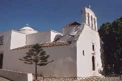
[If you come from Chóra by bus, you can see the church of the Panagía i
Evangelístria i Protótronos opposite the spot where you get off the bus: this
church contains some beautiful wall paintings and especially a marvellous
ikonostási; unfortunately though, the church is usually closed.]
The Panagía i Evangelístria in Chalki.
(0h00)
Leaving from the bus stop and the church you follow the narrow street
opposite the church, in between a shop and the pharmacy (hiking sign
Drosianí / Moní 1h05 + [4]). After about 60-70 metres you get to the
distillery Vallándris; this "ergostásio kítrou" or "working place where
kitron is produced" is one of the distilleries of Naxos where this
famous lemon drink is made. The working place is worth a visit and you
can buy all kinds of varieties of this tasty drink…
[If you do not have enough time to pay a visit to Agios Geórgios O
Diassorítis
on another occasion, you can first take a right (sign) and after 3 minutes you go left
for 1 more minute. Afterwards, you can return the same way you
came...] A little further on you walk on a beautiful sunken road.
The path between Chalkí and Tsikalarió.
You continue on a nice path between walls and olive fields and go walk
through a gate made of pallets [5]. Further on you go through yet
another gate made of reinforcing steel. After 5 minutes you continue
across a fairly broad and stony river bed, under a plane tree, and you
arrive in a landscape dotted with pale rocks.
(0h11)
The trail continues on the opposite side of the river bed ([5], red dot
and blue arrow). After another two minutes you reach a stony road which
you follow to the left for a while. Then you take a right (sign and
dots, [5]); the road soon turns into a nice and wide path again.
[To the left, you notice the beginning of walk [7] – hiking sign Sagrí
1h50.]
The little white church of Tsikalarió.
(0h18)
You continue diagonally to the right into the village, on a paved street
(hiking sign Apáno Kástro 35’ / Potamiá 55’), and 30 meters further you
keep to the left [5] – and so you walk through the village. After a few
minutes the street turns into a concrete road and you already leave the
village, while keeping to the left [5]. Some 5 minutes later
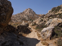
you arrive at a height and you can see your path continuing in
front of you, with a beautiful view of the Apáno Kástro (sign and dots).
You now proceed in a landscape with large boulders and you walk between
stables.
(0h26)
After another 7-8 minutes, there is a little side trail to the left,
between rocks: it leads to a necropolis of the 8th century
B.C.
[If you follow this vague trail, that fortunately is marked by a lot of
cairns, you will get to the base of a circular wall. This detour is also
interesting, because you find yourself here in the middle of a real
lunar landscape and because you enjoy a perfect sight on the Apáno
Kástro.
Back on the main path, you then come to a sandy road, but almost
immediately you take a left and you continue on the path that runs on
the right of a wall. (0h30) You walk through a gate made of metal remains: the trail is grassy, then sandy and it continues on the right of a wall; further on, there is also a very beautiful passage between the wall and large boulders, with the Kastro Apáno in front of you.
The path continues in a rocky landscape...
You then reach an nice stretch on worn away rocks and finally you arrive
under a high wall, with to the left the simple church of Agios
Pandeleïmonas.
[Through a breach in the wall and a little gate, you can arrive at the
tiny church – a little bit further there is a sign "Kástro Tsikalarioú".
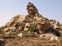
The Apáno Kástro.
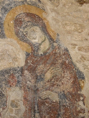
A remarkable rock on your right. Some frescoes in the chapel of Agios Andréas.
You continue on the right of the chapel, and shortly thereafter the path
is nicely paved: you may continue to walk on the large curbs, the
remains of an old kalderími. Further on, it is better to follow the path
to the left of the curbstones. After another 3-4 minutes the curbs bend
to the right, the old road makes a curve to the left and passes a little
bridge, and the road veers to the left and to the right, towards a
gravel road. |
(0h53)
You thus arrive at this gravel road, where you take a left (red arrow
and dot); you curve to the right and you follow the road for 7-8
minutes. Far away, in front of you, there is the village and the white
church of Mési Potamiá. After a steep descent on concrete, you get to
the main road and you cross this road - a blue bench invites you to take
some rest and to enjoy the view over the beautiful valley of Ano, Mési
and Káto Potamiá.
(1h01)
Opposite the concrete road, you can go down in the valley on a little
concrete road (red dot and [5] on a pole), which later turns into a
concrete staircase on the left; the steps meander to the right and the
left, and after 3 minutes the staircase reaches a little square with a
fountain (the Platia Filothéou Orfanoú) – the name of the street is now
Odos Nikoláou Orfanoú. You are in Ano Potamiá and you get here to the
itinerary of walk [6]. To continue you have to
take a left at this point, into the Odós Giampoúra. It is really worthwhile
though, to first go up on the right, through the village.
After about three minutes you
get to the marvellously shaded and large terrace of the tavern I Pigí. In front
there is a well with plenty of water and higher up to the right you can see the
large, modern church of Agios Ioánnis Theológos. [On the right of this
church and across the asphalt road you find the beginning of the marvellous
trail to the Koúroi (see the hikes from Mélanes).]
(1h07)
After a possible break, you return to the Platía Orfanoú. There, you continue
straight ahead, in the Odós Giampoúra
([6] and hiking sign Káto Potamiá 40' / Agios Mámas 1 hour)
and after two minutes you go down, keeping
to the right for a while. You then get to a wonderful spot: the path arrives in
a narrow valley along a stream and to the left of the restored water mill “Nerómylos
tou Grylláki.
(1h14) You
take a left [6] and the path follows a stream full of water (19th of
May 2004 and 22nd of September 2011), with little bridges, benches
and lots of shade. At the second bridge you keep to the right (sign).
You can take a left or a right - this walk follows the upper path (right)... [This walk follows some
paths that run higher in the valley. If you prefer to follow the bed of the
river, you can follow another of the two walks from Ano to Káto Potamiá…]
You thus keep to the right
and go up until you get next to a chapel – you get to a concrete lane, which you
follow to the left (sign). Then you go down on a beautiful path, in the
direction of the church of Mési Potamiá; after about three minutes you pass this
church deep underneath. You continue to follow the paved main road straight
ahead – it is painted in white all the way. For the next couple of minutes you
walk on a concrete path, which runs horizontally – you do NOT descend further to
the left, in the direction of Pýrgos Kókkou (sign). You thus pass underneath the
school of Mési Potamiá. (1h24) You continue straight ahead (there is another sign on the left pointing to Pýrgos Kókkou): for a short while you now follow a marvellously paved trail; you then continue for a couple of minutes horizontally, above the valley with olive trees.
The nice path between Mési and Káto Potamiá. Some five minutes later there is another sign on the left pointing to Pýrgos Kókkou. At this point you have to take a right on a concrete path. [It is really worthwhile
to make a small detour here, and to first go down on the left, in the direction
of Pýrgos Kókkou and Néo Perivóli. In this way you can have an even better view
on the fertile valley with lemon and orange trees. After 6-7 minutes you reach a
house, where there is a junction to the right (note the sign Néo Perivóli).
Immediately thereafter you get to a valley with a beautifully constructed trail
– there are small bridges, plenty of water and also some oleanders. The path to Néo Perivóli. About three
minutes later you thus arrive at a wonderful garden (the "perivóli")
– through the open door you can even take a quick glance inside…
Néo Perivóli. You then go back
and after three minutes you take a left at the house; some 6-7 minutes
later you obviously take another left on the main trail in order to
continue.]
(1h33) You
can take a rest for a while and then you have to return slightly because the
road to Agios Mámas starts BEFORE you get to the church, on the LEFT (sign +
[6]). You thus go down on the left into the valley, you cross an irrigation
gutter and after about two minutes you cross the stream, which is bordered with
oleanders, on a concrete bridge. You then go up again on an earth, than concrete
or tiled path. Another 3 minutes further down you keep to the right (there is a
red arrow) and you continue for a while on a truly beautiful, narrow trail above
the valley. After a few minutes you reach a recent gravel road that you follow straight
on, but a little further and in a right turn, the trail continues straight (and
you do not take the path that goes up to the left!).This
trail describes a wide bend to the left. After ten minutes at last you suddenly
notice the ruins of the little church of Agios Mámas, on the opposite side of
the valley. On the right above these ruins you can see the remnants of the
episcopal palace. You now descend fairly steeply for about one minute, you cross
another little stream by stepping on some rocks in the water, and you continue
on a gravel road on the left. After barely ten metres you take a right:
the dirt road zigzags
right and left, but after a second right turn, you take a LEFT ([6] on a rock)
to continue on a few fields. You thus arrive at the left side of the church and
you should now climb some terraces to get to the terrace where the church itself
stands.
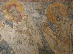
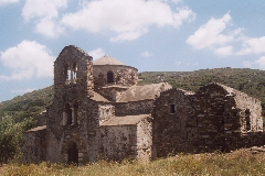
(1h53) The church of Agios Mámas dates from the 9th century and it is usually open; you might even discover some frescos inside.
Agios Mámas In order to
continue your walk, you should return down to the left side of the
church: you veer to the right on a vague trail and you get in this way
BEHIND the church. You proceed through a narrow valley and arrive to the
left side of the “palace” Ant.s Justinianus archiep NaxoPariensis "Antonius
Justianianus, archbishop of the islands of Naxos and Paros had this
palace constructed at his own expense, for the convenience of himself
and his successors, in the year of our Lord 1707".
The "palace" of the archbishop... This deserted spot
radiates an atmosphere of lost glory – which events have taken place
at this lonely place, in earlier days…? (1h55) You leave by taking the earth road that continues to the west, between the "palace" and a big reservoir; after 100 metres you go sharply to the right and by describing a large bend you thus arrive easily at the river in about eight minutes. (2h02) You climb up for one more minute, you walk for another
eight minutes on a magnificent trail above the valley. Next, when Káto
Potamiá is visible already, you go down on the left on a small
concrete path. You get to a bridge and you climb up for another minute
to reach the church. You go to the left, until you get behind the church; about ten metres further you find a tiled little street, which you follow up to the right. You continue on the main street (there is a small gutter in the middle of this road) – the final stretch is in concrete. You thus get to the asphalt road. (2h16) At this point you can either wait for the bus (only in Summer) or call a taxi.
To
get the printer-friendly version |
|