|
Evaluation:
This
long
hike is rather exceptional,
since it is the only walk
that leads
to the temple of Demeter and
starts from Chalkí. It was recently
signposted (with hiking signs,
but not always with trail
markers [7]). The landscape is
nice, and the trails and
paths are too.
Deserves **.
[The
translation of this walk was
made with some help of Google translate - so, please, do not mind the
mistakes...]
Estimated time:
The
actual walking time (AWT) until Ano Sagrí is about
1h40, and from there it
takes only 25 minutes to reach the
temple of Demeter
– the AWT of the way out thus amounts
to about 2 hours. The return
lasts a little longer,
so the total actual time is about
4h25. The total time however
(TWT) can amount to the double, to 6-7 hours.
Road description:
(0h00)
[If you arrive in
Chalkí by bus, you can see the church of the Panagía i Evangelístria i
Protótronos opposite the spot where you get off the bus: this church contains
some beautiful wall paintings and especially a marvellous ikonostási;
unfortunately though, the church is usually closed.]
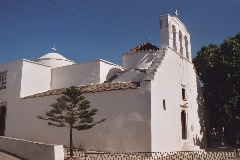
The Panagía i Evangelístria in Chalki.
(0h00)
Leaving from the bus stop and the church you follow the narrow street opposite
the church, in between café Chalkí and the pharmacy. After about 60-70 metres
you get to the distillery Vallándris; this "ergostásio kítrou" or "working place
where kitron is produced" is one of the distilleries of Naxos where this famous
lemon drink is made. The working place is worth a visit and you can buy all
kinds of varieties of this tasty drink…
Opposite Vallándris you take a narrow street on the right and after 150 meters -
where the pavement turns into concrete – you take a left on the first street
(red dot), then immediately right and then immediately left again (red dots and
a walking sign to Apáno Kástro). In this way you leave the village and you
arrive at a nicely paved path between walls and olive trees. One minute further
you arrive at a junction: you go straight ahead (red arrow to the left).
[The path to the right leads to Agios Geórgios O Diassorítis (sign).]
A little further on you walk on a beautiful sunken road.

The path between Chalkí
and Tsikalarió.
You continue on a nice path between walls and olive fields and go walk
through a gate made of pallets. Further on you go through yet another
gate made of reinforcing
steel. After 5
minutes you continue across a fairly broad and stony river bed, under a plane
tree.
(0h11)
The trail continues on the opposite side of the river bed (wooden sign, red dot
and blue arrow). After another two minutes you reach a stony road which you
follow to the left for a while. Then you take a right (sign and dots); the road
soon turns into a nice and wide path again.
Past a little concrete bridge the monopáti is paved and it climbs until you
reach a small square with the little church of Tsikalarió – after about 6-7
minutes. On the right you notice a well and a washing place. At this point you
have a great view on the valley filled with olive trees, with Damariónas on the
opposite side. Further to the left you can distinguish the larger village of
Filóti and then Chalkí, all the way to the left and submerged in olive trees.
[Continuing
straight, you could go to the Apáno Kástro and Potamiá.]


The white little church of
Tsikalarió.
(0h20) You now take the small
concrete road that descends to the left: you pass a large church, and after 3
minutes, you cross the asphalt road. You continue to go down on the opposite
side (small sign Damalás / Damariónas) and, at the moment that the road comes to
a dead end, you should keep to the left (small sign). You go down between the
houses of the hamlet of Chímarros and you thus arrive at a cross street that
ends on the left side near a chapel: here you continue more or less straight
into a stepped street and you descend into the valley, while keeping to the
right. You cross the river bed and you continue until you arrive under a large
eucalyptus: a cemented path continues to the left to Damalás and Damariónas
(small sign), but you should follow another path, next to a black water pipe and
to the right of some sharp rocks.
(0h26) Soon, the pavement becomes
nice and after 2 minutes, you keep to the right at a bifurcation; a few minutes
later, you arrive at a cross gravel road, which you will follow to the left for
8 minutes – with on your left side a beautiful view on masses of olive trees and
on the Zas.

View over the plain of Tragéa.
(0h38) You thus get to the asphalt
road (sign), but BEFORE you reach this road, you turn RIGHT: you pass to the
left of a chapel, then you go under the road while veering to the left, then you
veer to the right again.
The trail is narrow and sometimes overgrown, it continues for some time between
walls, it goes up and still arrives between walls (with a small gate). You go
down and you get to a dirt road with on the right side a construction company:
here you continue to the right until you reach the main road and you follow it
for 5 minutes to the left, passing next to the Shell gas station.
(0h53) You then take the first path
that goes diagonally to the right, to the right of a cemetery of old machines;
you veer right, then left and after a few minutes you pass to the RIGHT of a
sharp stone, where the small road continues. Soon, you see how the trail
continues far ahead.
A few minutes later, you should pass through a gate in reinforcing steel and a
little further – pay attention – you keep to the right and continue to the right
of a wall on a path that runs over rocky slopes. Two minutes later, there is
still a gate, then the path becomes wide and paved.

A broad path towards Agii Anárgyri
and Ano Sagri.
(1h08) This beautiful stretch ends on
a gravel road, which you follow straight, next to two large houses. Shortly
after, you keep to the right between two upright stones (red mark) - further,
you already see the tower of Paleológos and the chapel of Agii Anárgyri. You go
down and, after crossing a riverbed, you continue on concrete between 2 houses;
later on, you keep to the right of course and just over a minute later, you
reach the path that leads to the right to Agii Anárgyri (small white sign).
[The detour takes only 4-5 minutes: the trail becomes concrete and after a
concrete turn, you immediately should go left through a gate in reinforcing
steel. You thus arrive at a small road between the residential tower of
Paleológos and the chapel of Agii Anárgyri. You can continue to the left of the
fence up to the chapel, from where you enjoy a beautiful view of the tower. You
then return to the main trail.]

The tower of Paleológos.
(1h17) You continue to follow the
small road, you pass a driveway on the left, but a little further, you take the
path on the left side, to the right of a wall – this is 2-3 minutes beyond the
junction towards Agii Anárgyri. This nice trail is dug in and leads you in less
than 5 minutes until the asphalt road, next to a bus shelter and a hiking sign.
(1h24) You take the asphalt road that
leads some 10 meters to the left to the village of Sagrí (road sign "Demeter
Sanctuary"). You follow this road for 3 minutes and then you see a paved path
that comes from the right (hiking sign "Dimitra's Temple"). You follow the trail
to the left, it continues parallel to the road (red 7).
(1h29) About 2 minutes later, you
veer right to cross a small pine forest, where there are also some benches. When
the trail turns right again, you continue straight on a small dirt road and so
you get to a paved road that leads to the left to a large church - you go down
this road to the RIGHT. You cross a concrete road and then you go straight on a
wide paved slope, again between the pines. You arrive at the asphalt road, where
you go up on the concrete slope to the right of a monument; you then descend (a
red 7 and a red mark) the stairs to the right and you arrive at a concrete road.
You go left this time, but when that road turns right underneath the houses and
comes to a dead end, you go up the cobbled street to the left (next
to the double heavy electricity pole) – you do not take the street in front of
you with the "dead end" sign). You arrive in this way near a restored tower and
the church. In front of you, you see the monument to Xenákis and a hiking sign
to the "Naós Dímitras" + a red and white trail marker [7].
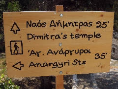
The hiking sign
indicating the path to the temple of Demeter.
(1h38) You descend the paved stairs
to the right of the bust and you take immediately a right onto a narrow concrete
road – mind the red drawing of a temple on the wall with an arrow to the right
...
The road soon becomes a gravel road; you descend between agaves and after 5
minutes you pass next to the path that leads to the Naós Agíou Nikoláou (old and
new sign).
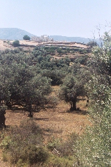
You continue to follow the path straight ahead, on the right slope of the green
valley, and you pass below a small church; you go down a bit, then you continue
flatly again – in front of you to the left, you already distinguish the ruins of
the temple.
(1h50) After another 6 minutes, there
is a small concrete road that goes down to the left, but again you should
continue straight on a narrow path to the right of a wall (large red mark).
(1h54) About 4 minutes later, a nice
rocky path goes down to the left in the valley.
[The path that continues straight will follow the slope on the right side of the
valley, with a beautiful view of the temple site – you follow it on your way
back.]
View on the temple of Demeter. |
|
We gaan dus
links de vallei in
tussen muurtjes (wandelbordje + [7]), in de goede richting naar
de tempel toe. Het pad buigt eerst rechts, maar bij
een stalletje ([7] en rode stip) draait het weer links om een valleitje
over te steken, links van olijfbomen [7].

A nice path leads to the temple.
You thus descend to the left, between walls (sign and [7]), straight to the
temple. The trail turns first to the right, but near a small stable
([7] and red marks) it veers left again to cross the valley, to the left
of olive trees [7].
Soon you cross the muddy bed of the river (there is still a little water, 2 May
2013), then you go through an olive grove diagonally to the right, towards the
angle of a small ruin (there is a low gate and a red mark). You climb slightly
next to a heavy water pipe (red marks), and after a second low gate made of
reinforcing steel, you get to a terrace. You pass below the temple and to the
right of a wall (red mark) and you arrive to the left of the little museum -
here you open the heavy bolt of a wide gate, possibly with the help of a
stone... Now you can go up to the left to the temple site.
(2h00)
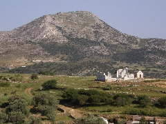
The temple itself is
nicely located, with a view on the gentle valley towards the south. It dates
from about 530 BC and in the 5th century AD it was converted into a
church. Later on it was completely destroyed and many of the building elements
were used for the construction of the chapel of Agios Ioánnis – and even for the
construction of some farms. Only in the year 1949 the site of the temple
attracted attention and after endless puzzling a part of the temple and of the
Christian basilica was reconstructed – with a really nice result. 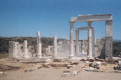
The temple of Demeter.

The absis of the
Christian basilica.
(2h00)
From the temple, you retrace your steps up to the rear of the museum, and then
you go round to the entrance - a short visit is quite interesting...
You then take the paved path that arrives first near the official entrance, then
you descend until the asphalt road.
(2h06)
You turn right and after a little more than 6 minutes, you will see a beautiful
trail that will lead you back to Sagrí (sign "Pros Káto Sagrí) – this trail is
very obvious. After 2 minutes and also after another 6 minutes - next to some
stables -, you do NOT take a left of
course. On your right side, you enjoy a beautiful view on the temple and on the
hill of the Kástro Apalírou.
View on the temple of Demeter
with in the background the hill of the Kástro Apalírou.
A little further, you can rest a moment on a bench...
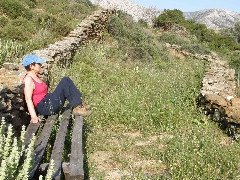
A moment of rest on a bench
along the path...
You continue on this beautiful trail with no problem and after 15 very pleasant
minutes, you arrive underneath Ano Sagrí. After a short stretch of concrete, you
climb the 44 steps to the left and you arrive in this way next to the bust of
Xenákis.
(2h45) You take the paved road to the
right of the residential tower [7] - not the asphalt road down to the right -
and you arrive next to the double electricity pole, where you follow the small
concrete road that descends to the right. Just before the road sign Stop, you go
up the stairs on the right, but at the top, you again go down to the left. Once
arrived at the asphalt road, you continue straight between the pine trees, you
cross after a minute the little concrete road and continue straight on the paved
little street leading to the large church. At the foot of this church, you take
the little dirt road on the left, which soon leads to the corner of the paved
path. You follow this path straight, you arrive next to the asphalt road and you
follow the path for another 2 minutes. When the trail turns left (sign), you
continue to follow the road for another 3 minutes and so you get to the main
road. You go to the left for 10 meters and take the path to the right that
begins next to the shed (hiking sign Agii Anárgyri 15
+ a red 7).

The hiking sign for
path [7] not far from Ano Sagrí.
(2h59) The beautiful trail leads
after 4 minutes to the gravel road, where you go right. You see the tower of
Paleológos on the left and so you reach after 3 minutes the path leading to Agii
Anárgyri (sign). You continue straight on, after a few minutes you pass between
the 2 houses, you cross the small valley and just past the 2 upright standing
stones, you arrive at a cross-road.
(3h11) You keep to the left, the
small road goes up and, in a curve that rises to the left, you continue on the
nice trail to the left of a wall (red mark). The paved trail is beautiful and
wide - notice the small Byzantine church on a small hill on the right.

The splendid path
between Agii Anárgyri and Tsikalarió.
(3h18) You go through a gate in
reinforcing steel after a few minutes, you continue a little time on rocky
ground between wide walls, and you thus arrive at a kind of small plateau next
to some drinking troughs. Here you continue straight on a small dirt road and
you still continue straight when a road arrives from the right - and so you
arrive in a turn with a gate on the left side.
(3h28) On your left, you have a nice
view of the top of the Apáno Kástro, but here you veer right in order to follow
the dirt road, and then left again; you pass to the left of the "cemetery" of
old machines and you finally get to the asphalt road. You follow it to the left
for 5 minutes and so you pass the gas station.
(3h36) Once arrived at the
construction company, you go right into the small dirt road, just opposite a
chapel. The concrete begins just after the company, and this is where you take
the path on the LEFT between walls. You go up on a grassy path – at the top, you
are already see Chalkí, far ahead. You descend between walls and the trail
becomes narrower. You continue to the right of the road, but at the end of the
trail, you pass to the left underneath the road, then you take a right – so, you
pass to the right of the chapel and you still get to the road.

The hiking sign at
the beginning of the path to Tsikalarió
(3h51) You now take the path going
diagonally to the left (sign "Apáno Kástro 1 hour"): this small dirt road is
nice and continues between fields, again with that beautiful view of the plain
of Tragéa - with Moní to the left, then Chalkí and Keramí, a part of Filóti and
the Zas. You pass under the chapel of Agios Merkoúrios and next to Taxiárchis -
and soon you see in front of you Tsikalarió...
(3h59) After 7-8 minutes, there is a
bifurcation where you take the grassy path that starts diagonally to the right:
the path narrows and becomes a nice trail between walls. It gets to a cross
trail, which comes from Damariónas, and you turn left (small signs). You
continue more or less straight below a eucalyptus, you cross a river bed (signs)
and you continue just opposite on a concrete street with steps.
You arrive to the left of the chapel - and you do NOT go left here, but you
continue more or less straight following a cemented street between walls and a
white house. So you reach a small concrete road (signs) that you follow to the
right until you get to the asphalt road.
A big sign and a smaller hiking sign (Tsiakalarió + Apáno Kástro) send you
straight ahead: you pass next to the nice church and you get in this way to the
paved main street of Tsikalarió with the parking lot – just opposite you see the
little white church and
the washing place.
(4h09)
You take a right next to the church and you find a nice trail that descends
further into the large valley. The path soon becomes a little sandy road and
after some 6-7 minutes it reaches a rocky clearing. Over there you go up the
stony road on the left (sign Chalkí), but you soon discover another path on the
right (sign and red dot). After 2 minutes, you cross a fairly large bed of a
river and you continue straight ahead through a gate in reinforcing steel (sign
and red dot).
(4h18)
You walk between high walls, and then there is a nice stretch with a sunken
road; after another six minutes you keep right – the path to the left leads to
Agios Geórgios O Diassorítis.
This is where the paved path begins that that leads into the village. You
meander through the streets, right, left, and again right on a side-street, and
so you come to the distillery Vallándris.
You can reach the pleasant outdoor terrace of O Giánnis by taking a right at
Vallándris. If you take a left, you arrive at the asphalt road with the bus
stop. (4h28)
To
get the printer-friendly version
with only the text
in one column,
click here.
|