|
Chóra - Páno Stavrós - Kallítsos - Moní Taxiárchoon - Vounáki - Páno Stavrós - Chóra |
||
|
Evaluation:
This tour can be a nice alternative to the walk through the interior of
the island, passing through Kallítsos, the monastery of Taxiárches,
Galaní and Panagiá and eventually returning to Chóra.
The path to Kallítsos is indeed one of the most beautiful trails
in the Cyclades, but the circular walk requires you to follow a few long
stretches of asphalt. (0h12)
The trail goes
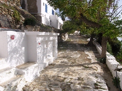
up again now (=), sometimes it even turns into a nice flight of stone
steps (= and [1]). Almost on top, at the foundations of a stone
building, there is a path to the right (to Livádi or Psili Ammos, see
the hike Chóra - Psíli Ammos). Your trail, however, goes straight [1],
in the direction of the chapel with a small arch. The views on Chóra
behind you and on the bay of Livádi get the more and more beautiful. (0h26)
Your next
objective now is the chapel with the little white arch, which you see
halfway to the top of the big hill on front of you, a hill with lots of
aerials on top. The trail clearly continues to the left [1], in between
walls: the sunken path is sometimes blocked by vegetation, but after
almost 5 minutes, you get to more open ground, with a little valley in
the middle.
(0h30)
Attention: there are two paths here and you should take the left path,
to the left of the valley (red arrow + [1]). The chapel of Páno Stavrós, between Chóra and Kallítsos. Above you have a
wonderful view on Chóra, Livádi, the beach of Agios Ioánnis and the
island of Sífnos. Therefore, this is the ideal spot to take a break; the
chapel is open, but also the steps in the shade are very inviting to sit
for a while! (0h44) At this chapel a beautiful kalderími starts off (=) and you will follow this one until Kallítsos. You go up gradually, in a rocky and very impressive landscape with great views on Agios Ioánnis, Psili Ammos, Livádi, the little island of Vous, Sífnos and Chóra behind you. The kalderími between Chóra and Kallítsos. Often, there are
nice curbstones, sometimes a nice pavement, and especially after some 18
minutes, there is a stretch with a beautiful pavement. You might even
wonder who has ever put all this work into this wonderful trail. After a
climb of about 23 minutes you reach a kind of pass on a protruding cape
[1]; this is Vounáki - you can now see Kallítsos and also the large road
above it. [If you prefer to
follow a shorter route to the monastery, without going through Kallítsos, you could take the small road that goes
up here to the left, to the gravel road that you will follow during your
return route. You could, after 4 minutes, follow this road to the right
- and so you could reach the monastery after a little less than 40
minutes, while the route that continues straight to Kallítsos will cost
you 1h30…] (1h07)
You descend to
Kallítsos for about 10 minutes – after 10 minutes, there is a triangular
spot, where according to the map a path mounts to the left. It finally
gets to the gravel road you will follow later on (see under point
2h08), but in October 2015 it
was too overgrown.
The "platía" in Kallítsos.
(1h27)
After this break, you
continue straight,
then you take the nice staircase that rises to the left; you veer to the
right and you reach a wide paved street that leaves the village while
going up. The street becomes a concrete road and also beyond the very
last house, you continue to go up on concrete. You go up to some ruins
where you veer left and so you get to the actual route of walk [10]
(hiking pole).
You pass to the right of some ruins and get to a very rocky climb – at first to the left of a ruin, then for quite some time between walls. You have a beautiful view of Kallítsos and you arrive after about 8 minutes at the top, next to a large round ruin. |
(1h46) You veer slightly to
the left (=) between the walls and you still go up a bit until you get
to a slight depression between your hill and the next one - on the
right, you enjoy a nice panorama on Kýthnos and on the islets of Vous
and Pipéri. You continue flatly for some moments, but at the end of the
depression, you do NOT go up to the right between walls, but you keep to
the left (=) in order to follow a clear path towards a grove. After an
easy end, you go up again, always with a beautiful view of Kallítsos and
the bay of Kéndarchos. About 5-6 minutes later you descend slightly to
the left (=) and you reach an easy path that later on continues next to
ruins until a cross valley with a lot of vegetation. [Walk [10] continues to the right here – see the hike Kallítsos - Profítis Ilías - Triantáfyllos - Panagía Skopianí - Kallítsos...]
The
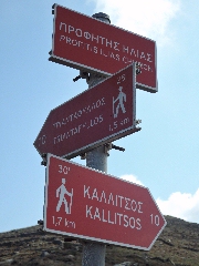
chapel of Profítis Ilías and the hiking signs for walk [10].
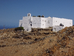
The impressive monastery of Taxiárchoon
This monastery was
built like a fortress, it is situated some 100 meters above the sea and
it dates from the 16th century. You can enter the monastery through a
very low door – if there are not too many tourists the only remaining
monk will offer you some loukoúm and he will show you the church with
its beautiful ikonostási, originating from 16th century Russia. But often the door remains closed...
(3h09)
Near the sign [10], you thus continue straight on: the dirt road is
quite pleasant and follows the slopes of the Diaséla, above Kallítsos
and the path that you just have followed. After 8 minutes, a small road
goes left, in a bend and next to a pole.
To
get the printer-friendly version |
|


