Filóti - Agia Marína - Pýrgos Chimárrou |
||
| Evaluation:
This is a very lonely hike, on the slopes of the highest mountain Zas;
in a fairly adventurous manner the hike then continues to the ancient
tower of Chimárrou. For the second part of this hike you need a decent
sense of direction, but the desolate and beautiful nature is absolutely
worthwhile. This hike deserves an evaluation of **. Estimated time:
You can catch the bus to Filóti and then hike up through the village
till the small chapel of Agia Marína – this will take about 35 minutes. A beautiful trail gets you
to the junction in about half an hour, where you could take a right and
go up to the summit of Zas. Next, there is a long stretch of about 75
minutes to the twin hills 524 and 523 (Leproú). From this point you can
finally distinguish the tower: on the map there is a path, but it is not
very obvious. The following descent of about 25 minutes is really
difficult and then it takes another 15 minutes alongside the asphalt
road to get to the Pýrgos Chimárrou. All together this makes for three
hours of actual hiking time – when taking into account some pauses you
will devote about six hours (TWT) to this hike. The only possibility to return
to Chalkí is by taxi – so do not forget to write down the necessary
phone numbers in advance! Route
description:
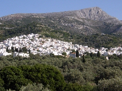
Panoramic view on Filóti with the summit of the Zas (seen from the road next to Chalkí). [It is usually quite busy in the neighbourhood of the bus stop in Filóti: at this point the roads to Chalkí, to Agia Marína, Apíranthos and Apóllonas and to Damariónas come together. Most of the taverns and shops are situated in the vicinity.]
(0h00) Between the
kafenío O Plátanos and the "paradosiakó pantopolío " (traditional
grocery shop), you climb the wide marble staircase (hiking sign Agia
Marína 1 hour / Zas 1h55 + [2]): in this way, you get to a square with a
plane tree, that lies to the right of the church of de Panagía
Filiótissa. Here, you go down to the right ([2] on a pole) and you
continue straight at the next crossroads [2].
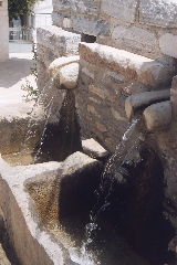
The fountain near the Pýrgos Barozzi in Filóti.
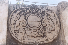
The old coat of arms on the Barozzi-tower. To the left of the
tower, you descend the concrete slope, but immediately you should take a
left [2]: the little concrete street becomes a path, to the right of the
last house.
(0h05) You get to a
nice cross path, with a gutter. [To the right lies the
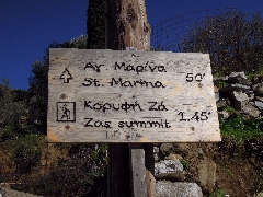
Kálamos source, with a washing place.] You take a left [2] and soon you arrive again between houses, where you get to a concrete road. You continue straight [2], but after 1 minute, you take the concrete staircase to the RIGHT - there is a hiking sign "Agia Marina 50 ' / Zas 1h45" + [2].
The hiking sign for the hike to the Zas and the tower of Chimárrou. You soon get to a steep
stony path, which after 9 minutes describes sharp turns right and left. [At the chapel
tree there is some space to park, so apparently you can get to this
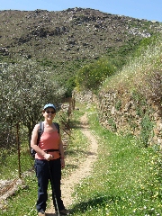
chapel by car.] (0h35) Today you thus follow the broad and beautifully shaded trail no. 2, on the right of the chapel – there are no trail markers, but there is a signpost in Greek to the Koryfí tou Za, the summit of the Zas. Slightly further you get next to a house and over there you take the trail that passes on the right-hand side of the house. The trail is steep for a while and then you walk horizontally on this nice path. Some 5 minutes later you have a nice view on the Zas in front of you.
The nice path and the beginning of the climb of the Zas.
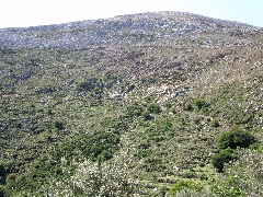
View on the slopes of the Zas.
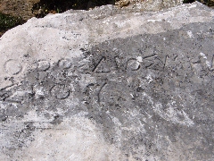
The inscription "Oros Diós Melosíou". |
(0h49) Shortly thereafter you pass some drinking troughs with another bench besides them. You go up steeply now on a trail with a lot of rocky steps – if it were not for the sea on your left-hand side, you could really imagine yourself in the Alps – also because of the mountain goats. The path meanders up nicely and then you reach a flatter stretch again. Over here you have to watch out, because the trail splits up: our trail continues straight to the tower of Chimárrou. [On the right you can
see a
couple of
obvious
cairns –
they
mark the trail that goes all the way to the top of the Zas.]
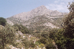
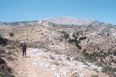
Panoramic view on Zas mountain, from the road Chimárrou - Filóti. You walk on the right-hand side of a tall wall, but after a couple of minutes you leave this wall to continue on a very beautiful stone path. Later on you descend into a valley with some trees and with lots of goat. You go through an open gate and you move on in south-western direction, underneath a couple of trees. At first you walk again on the left-hand side of a wall, actually going too much to the south-west. After a short while though, the fairly obvious trail curves more to the left. You go down amidst the trees and the bushes and you reach a beautiful and flat path – this path now goes straight in the right direction, so to the south.
The monopáti with Zas mountain in the background. After 7-8 minutes you
arrive at some large trees, located in a depression of the hill. You continue by
curving to the left; for a short while you walk on he right-hand side of a wall,
but then you should go a little further to the right on a vague trail, running
on a rocky and fairly flat side of the hill. You follow the stony hillcrest, you
get to the right of a crumbled away wall and you go slightly down on a fairly
obvious trail. In front you get a magnificent view on the island of Amorgós,
with above it the typical rectangular cloud; to the right there is the island of
Irakliá, then the flat island of Schinoússa, the 2 Koufoníssia and beyond the
higher island of Kéros – all the way to the left there is the isle of Donoússa.
This is a windy, but absolutely great spot.
You follow the gravel road for some five minutes, first going to the
right and then meandering to the left. You finally get to a very ugly, modern church. This spot is still
littered with building materials and debris, and you can also notice a
new bell on the ground (on the 27th of May 2004). This spot
is windy and not very pleasant, but the panoramic view on the island of
Amorgós and on the smaller islands is still magnificent. You continue
on the left-hand gravel road and you go down for a short while. Already
in the first bend though, you find another trail going straight ahead. This
path goes towards the south-southwest and at first it is fairly unclear.
You should move on
towards a point between the lowest tree and the lowest but one tree in
front of you. In this way you get to a more obvious trail, which runs
about 100 metres above a stable. You are now at an altitude of 550
metres. From here you can see the trail continuing in front of you on
the hillside next to a wall – your aim is the depression between the
hills in south-southwestern direction in front of you. These are the
twin hills of Leproú, the one on the right-hand side has an altitude of
524 metres and the left-hand one – with a small pole on top (a
trigonometric point) – has an altitude of 523 metres. On the map the
trail runs between these two hills, but it seems a better idea to first
aim for the hill on the right. Watch out not to go too much to the left,
because you might end up in a very steep valley… After five minutes
you reach some skinny trees and from this point your aims already seems
a lot closer. The trail goes clearly to the right, but first you should
cross two side-valleys. After another 3-4 minutes you cross the first
small gorge in between some trees. You then continue on a vague path,
staying more or less at the same level, until you arrive at a very
picturesque spot between two trees. From here you can see an obvious
trail descending on the right and you can also distinguish the lines of
paths continuing on the opposite side – that is where you will finally
end up. This means that after the descent between the trees you will
have to climb up again quite a lot in order to reach the right trail.
But maybe, it is a good idea to first have some rest here – this is an
ideal picnic spot, since you can sit on a rock under a tree. The only
sounds you hear are the bells of the goats; you can see the sea, the
islands and the cliffs of the isle of Amorgós, far away at the horizon
beyond the sea. After this pause
you descend for some three minutes until you get to the narrow gorge.
You then go up again to the left straight away, till the lowest path.
You continue to go up in the same direction for some five minutes;
thereafter you go a little higher up in order to arrive at a
second path. You now walk on a clear earth trail, but do not go too much
down or to the left! The slope is longer than expected, but you should
continue straight towards the south, until you notice the asphalt road
in the green valley in front of you. Also at this point you should not
proceed in the direction of the valley. You should continue straight
ahead on a barely visible, red-brownish trail between grey rocks,
towards the hilltop directly in front of you. At last you arrive on top
of the rocky and flat hilltop. The view is marvellous from here as well:
in front of you, in south-eastern direction, you can finally discern the
Chimárrou-tower at the far end of the road. And further away in front
of you, there is still the great view on the islands of Ios and Amorgós,
with in between the Small Cycladics. Over here the silence is
overwhelming… You now descend
towards the east, in the direction of the twin hill with the pole on top
of it. In the gentle valley between the hills you take a right on a very
vague trail. Do not try to descend straight towards the tower or the
road, because otherwise you will also have to cross a very deep valley!
You thus continue more towards the right, in south-western direction –
as indicated on the map. You go towards the trees, straight to the
extreme right-hand point of the asphalt road. At first there is
still a vague trail, but very soon this trail seems to disappear. You
should avoid to end up in the bed of the river; instead you should try
to get to the right of the bridge. At the end you go through a breach in
a wall and then you go through an iron gate. You thus arrive on the
asphalt road on the right-hand side of the bridge. You have descended
from an altitude of 524 m to an altitude of about 380 metres. You follow the
road to the left; some eight minutes later you can see the tower. After
about 12 minutes the asphalt road comes to an end and after fifteen
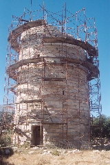
minutes all together you finally reach the tower. The Chimárrou-tower
is a Hellinistic tower, which belonged to a fortified farm. This tower
was in fairly good condition, until it was badly damaged by a stroke of
lightning quite recently – as a result the tower almost collapsed.
Restoration works began in 1997, but due to a lack of money the work is
not continuing – some piles of marble blocks in the neighbourhood
await better times… Inside the tower you can still see the spiral
staircase, which goes upward against the inner wall. Really
visiting this monument is impossible.
The Pýrgos Chimárrou. From this point it is a good idea to call a taxi – walking along the road on foot to Filóti would be 12 km, and once arriving there the bus would have left most probably.
For
the printer-friendly version |
|