Firà - caldera - Ia |
||
|
Evaluation:
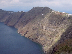
This is the most obvious hike you can make on the island of Santorini
and it will lead you - if you have not discovered them by now - through
the sister villages of Firà, Firostefáni and Imerovígli, going higher up
all the time above the caldera. It then continues through the expanding
housing in northern direction and it finally goes to Ia via a really
magnificent path. This hike offers so many changing views on the
volcano, the sea and the caldera, that it definitely deserves an
evaluation of ***.
Route
description: (0h00)
From
the bus square in Firà (when you get to Firà by bus) you have to
continue to the very busy square of Theotokopoulou. This is the modern
centre of Firà with a lot of travel agencies (the Santo Volcano next to
the Emporiki Trapeza-bank is a very decent one), banks and bars. In the
corner, in between the George's Snack Corner and the Pelican travel
agency you go left, in the direction of the caldera. You can then take
one of the three streets off the right, they all lead towards the higher
part of Firà. The stairs of Firá. [If you do not
take a left at the Archaeological Museum, but go straight instead, the
little streets higher up, on the left and the right of the catholic
Dominican monastery (the youth hostel is in this area as well) will also
bring you to the Nomikos Centre.] (0h10)
On the
left of the Centre you follow the tiled road and stairs, while you enjoy
the view – in front of you you can see the even higher situated village
of Imerovígli - here and there
there are markers [6].
Some
6 minutes later you pass the little church
Agios Gerasimos; you then move away from the caldera into a busier
street,
further, the alley has
an uneven pavement,
between walls built
with lava stone
[6].
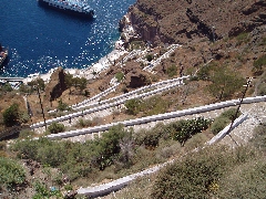
You go higher again on the path on the left of the main road and some 15
minutes after you have departed from the Nomikos Centre you reach the
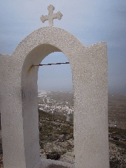
monastery of Agios Nikólaos – also this is a great viewpoint. [A little further,
you can go down on the left, via a steep path with approximately 100
steps, until the little chapel of Agios Geórgios. The view from here is
fantastic and there are some banks to have a rest. You can approach the
caldera even more by getting on the protruding cape.
A cape on the way from Firà to Ia.
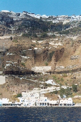
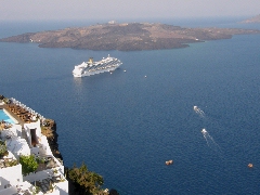
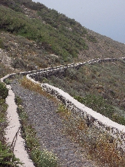
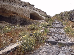
View on the caldera... You go up a bit, while keeping to the right, and then you continue first on a paved later on a concrete alley between houses. Now, you continue for another 10 minutes: you go up a little, down a little, all the time along new apartments and villas, some of them with swimming pools. You then finally get to a gravel path and then on the old, tiled trail, some 45 minutes after your departure from Firà. (0h45) This is only the temporary end of the buildings, because a little further down the path turns into a gravel road again. In this way you walk for another 25 minutes past apartments – new ones or under construction. Past the Pantheon de Luxe the road splits up: on the left you can take a path and then some concrete steps to descend to a marvellous spot: you are at the peaceful church of Agios Antónios, and a couple of picnic tables invite you to take some rest. If you have left a little later, then this is the ideal picnic spot. The other small road, going up on the right, leads to the snack bar To Monopáti and a hundred meters further on starts a concrete path.After a few minutes you see above and in front of you the white chapel of Agios Márkos (sign “Agios Márkos” + [4]). You follow the small concrete road to the right and beneath the chapel [4] and already after a few minutes, you arrive next to the sign "Profítis Ilias”, and to the left, you see the blue and white chapel of Profítis Ilias. 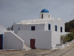 The little church of Profítis Ilías. |
[You could go up to the left to that chapel: in this case, you will follow during about 10 minutes a path with a nice view on the caldera; that path will join with the trail you will follow now, see below under the point (1h29).] (1h15) You do NOT go up to the left, but about 50 meters BEFORE the chapel, there is a paved path that goes right (hiking sign Vouniá 15 '). It is an alternative route which is marked with the number [3]. The beautiful trail that descends slowly, is very easy and offers nice views of the other, rather monotonous, part of Santoríni.
The trail [3], that returns from the chapel of Profítis Ilías towards Vouniá.
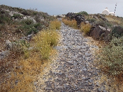
The pavement becomes stony after 12 minutes – it is here that the path
that follows the caldera, joins your path from the
left.
A very nice stretch...
Another 10 minutes later, there is a section where you
continue on gray ash, which also takes 10 minutes - no wonder the hill on your
right is called Mávro Vounó (= Black Hill) ...
The little chapel of Stavrós, 10 minutes before Ia.
(2h06) The descent lasts 10 minutes
and most of the time, you walk on a beautiful uneven pavement, sometimes on the
black or reddish lava - and so you come near another
chapel, also dedicated to Profítis Ilías. The path between Stavrós and Profítis Ilías.
(2h17) You continue while keeping to
the left - the right path leads to the small village of Finikiá, where also
begins the short walk to the beach of Baxédes.
|
|