General information
There is a wealth of ancient trails in Greece,
and in
many places,
the infrastructure of the century- old-paths has not been
destroyed by modern roads.
On many
islands, great efforts have been put in to restore the
cultural inheritance, also of the hiking trails. On
most of the
islands,
a number of trails are
now
marked by means of
hiking signs
and trail markers [1], [2]...
Municipalities, voluntary
associations and even schools
are engaged on
marking
and
on
the
maintenance of
trails.
For now, it is mainly the
islands of Sífnos
(www.pathsofgreece.gr
and www.sifnostrails.com),
Andros (www.androsroutes.gr)
and Tínos
who make the most effort
to mark and maintain
the
trail
network.
The marvellous descent from Apíkia to Chóra on Andros.
The path to Sinetí on Andros.
You can find any further information about a holiday in Greece on http://www.belvilla.co.uk/holiday-cottage-greece
HOLIDAY HOUSES
See the website http://www.casamundo.co.uk/greece/
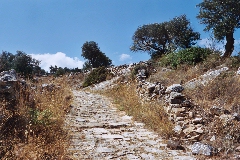
The beautiful path to Léfkes
on Páros.
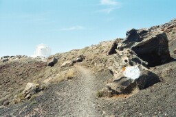
The monopáti to the Profítis Ilías on Kýthnos.

A
couple of publications on hiking in Greece
There are not so
many decent
publications available on hiking in Greece:
* Marc Dubin, “Trekking
in Greece”: very comprehensive with regard to the whole of Greece,
but rather old and not enough details on the islands we are interested in. The
indications are often too short as well. Still, this is an interesting
book!
* “Walking the Aegean Islands”, Graf Editions (translated from the German title: “Wandern auf den Kykladen”): beautifully edited, with many interesting maps. Maybe, certain hikes run along regular roads too often, or there is not even a trail you can follow. But still, this is a very interesting little book.
From the same author
you can also find the nicely published "Naxos and the Small
Cyclades", with 30 hikes.
In May 2006 the same author published "Western & Southern Cyclades", with 51 walks.
* Dans les Montagnes de Grèce, Editions Olizane, Genève: this French publication only contains two short contributions on the Cycladic isles and these descriptions are very general. For the rest of Greece this book might be useful.
* For people who can read Greek, there is a nicely illustrated guide on the Cycladic isles, "Kykládes", published by Explorer, Fidíou 18, 106 78 Athens. When talking about the islands of Amorgos, Andros and Tinos attention is also paid to hikes.The English version appeared in the year 2004, under the title "Cyclades. A complete travel guide." The three sections on hiking do no longer appear in this edition.
In March 2009 the first real good travel guide, solely devoted to the
Cycladic isles, appeared, in the series of Evasion, by the publishing
house of Hachette. This French travel guide is put together by the French
journalist Maud Vidal-Naquet and is entitled "Iles grecques. Les
Cyclades".
The
guidebook is expertly written and it shows great admiration for the
islands. In addition to a short chapter on Athens, it contains nearly all
of the inhabited Cyclades. The author gives very clear surveys of the
places of interest on each of the islands, with often very correct
personal appreciations (with symbols such as little stars and little
hearts for “places that touch your heart’).
In the second part of the guide, each island is discussed separately, this
time on a practical level – a lot of interesting websites and addresses
are given, with some real good addresses for accommodation and
restaurants; often, also useful facts are mentioned on hiking, diving,
horseback- and donkey-riding, windsurfing, etc.
There is also a short part called "Repères", with an overview
of the history of the Cyclades, a couple of pages devoted to Cycladic art
and some pages with interesting books, films and music.
Finally, there is a small chapter on the practical organisation of your
trip, with - again - many interesting addresses and suggestions.
This guidebook is nicely illustrated and it contains some nice maps –
there is only one word to describe it: a must!
* In 2020, the well-known English publisher for hiking and trekking
guides Cicerone published a very nice and handy booklet about some
Cyclades Islands, namely Walking on the Greek Islands - The
Cyclades.
This guide, written by the journalist and travel guide Gilly
Cameron-Cooper, first contains an interesting introduction to the
history, geology, flora and fauna of the Cyclades, as well as some
practical details.
Then 9 hikes are treated for Páros, 10 hikes for Náxos + 5 routes of the
"Náxos strada", which crosses the entire island from Pláka over Potamiá,
Filóti, Apíranthos and Kóronos to Apóllonas.
For Amorgós there will be 7 walks, for Santoríni finally 4. For each
walk there is a very clear and quite extensive description of the route
as well as a very clear and detailed map.
This English-speaking guide is a very useful hiking guide for these four
islands.
A
couple of other publications
If you would like to
read an old description of the Cycladic isles, there is the truly
interesting "The Cyclades" by J. Theodore Bent. This is a
great travel book from 1885 which was re-published in the year 2002
A lot of details
about Amorgós and the small Cycladics are to be found in "Amorgós
und kleine Ostkykladen" by Dirk Schönrock.
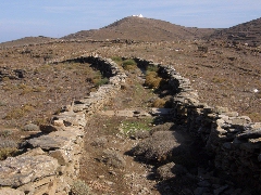
The path to the Profítis Ilías on Sífnos
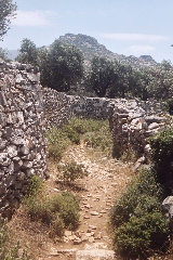
The path to the monastery of Panachrántou on Andros.
For Sífnos,
there are the interesting websites
www.pathsofgreece.gr
and
www.sifnostrails.com,
for
Andros
there is
www.androsroutes.gr.
We also
recommend to have a look at the elaborate site "Walking
the Greek Islands", the website of Harald Haughli,
and
on the site "Eva's Hikes in Greece"
For Tínos, there is the excellent site of Karolos Merlin, see http://www.tinos.tv
* Since 2002 some very good maps are being published in the series Topo; the publisher is Anavasi, 32, Boulis Athens GR - 10 557 Greece. You can buy these maps on the islands and on the airport; they are also available on the internet, see www.Anavasi.gr
In Belgium they are for sale in,
amongst others, the map stores of Atlas en Zanzibar in Antwerp and Ghent.
For other countries, see also www.mountains.gr
Almost
all the monopatia are indicated on these maps,
often with the official signposting. They are therefore rather
indispensable.
All the Cycladic islands are now
available: Kéa, Kýthnos,
Sérifos, Sífnos,
Mílos and Kímolos,
Folégandros, Síkinos, Santoríni, Anáfi,
Amorgós, Andros,
Tínos,
Mýkonos,
Sýros,
Páros + Antíparos, Ios
and
Náxos +
Small Cyclades.
* In the course of
spring 2009 a lot of new maps appeared in the series of
Terrain
Maps. These
maps are also very detailed.
See also
www.terrainmaps.gr
* At the Road Bookshop, Ippokratous 39, Athens, another interesting series of maps is being published. These maps give also some indication of certain monopatia. Andros, Mílos, Santoríni, Folégandros, Kéa, Páros, Náxos, Kímolos and Mílos, etc. are already for sale.
* For Andros, the association "Andros Routes" has
published, in 2014 and 2017, a very good map with all the way marked trails. See
www.androsroutes.gr
* In 2001 the local
authorities of Amorgós have published a beautiful guide in Greek and in
English; the title of this edition is "A Travelogue of Amorgos.
Footpaths of historical and cultural interest." It is a marvellous
little book with great pictures and with very good maps of the 6 official
hikes. For now, this guide is only available at the town hall of Chóra.

The start of the monopáti to Langáda on Amorgós.
The walk from Chóra to Egiáli on Amorgós.
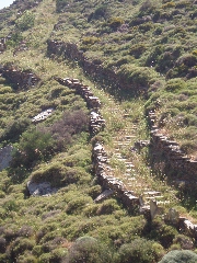
The marvellous kalderími to Chóra on Sérifos
The path from Firá to Ia on Santoríni
Some
advice before departure
* If possible, never
hike all by yourself – or take a cell phone with you. You can also
leave some information on where you go to at the reception of the hotel or
with the people you stay with.
* Always take enough
to drink.
If the indications
for these hikes are not sufficient, and if you do get lost in one way or
another, these suggestions might be able to keep you on the right track:
1. Many Greek
farmers tend to close off their own paths by means of a fence or some
thorn bushes – in general you should never cross these blockings, as
these paths usually come to an end on a field.
2. When you do get to one of those fields, never try to climb over the stone walls: this is not a good idea and in the end you will definitely have to turn back.
Hiking time
The
hiking time I give is always the actual walking time (AWT). When
calculating this time, no attention has been paid to pauses to rest, short
stops to take pictures, visits, picnics, etc.
It is obvious that the total walking time (TWT) is always considerably
longer; our experience tells us that the TWT is usual double the AWT. If
you decide to stay on a beach for a couple of hours, or if your pauses are
really long, then the TWT can even be extended.
Monopáti near Potamiá on Náxos