and 2023
Walking, hiking and trekking on IOS
BOATS IOS
-
Blue
Star Dilos/Patmos
-
Blue Star Naxos
- High
Speed 6 of 7
-
Champion Jet 1/Tera Jet
-
Master Jet
-
Super Jet
-
Adamantios
Koraïs
-
Artemis
WALKS
(last update on November 30th, 2023)
*** = very beautiful
**** = exceptional
+ Gpx = with Gpx-file
3. Chóra - Diaséli - Agios Ioánnis and back *** + Gpx
4 Chóra - Agios Prokópios - Chóra *** + Gpx
5. Chóra - Profítis Ilías - Agios Prokópios - Chóra ***
6. Chóra - Skárkos - Elliniká - Agia Triáda - Agios Prokópios - Chóra *** + Gpx
7. Chóra - Skárkos - Agios Ioánnis - Profítis Ilías and back ***
8. Mylopótas - Sapounóchoma - Klíma and back ***
With
108 km² and 1650 inhabitants the island of Ios can be considered as one
of the medium-sized islands of the Cyclades. It belongs to the
south-eastern islands and it is situated between Náxos and Santoríni.
Ios is fairly barren and mountainous, and the highest summit is the Pýrgos
(714 m). For their living, the inhabitants have always depended more on
fishing than on agriculture. Over the last decades the island has become a
tourist attraction; especially among youngsters Ios is known for its
bustling nightlife.
Excavations tell us
that already in the Cycladic (2800 - 2300 B.C.) and the Minoan (2000 -
1600 B.C.) eras there existed a highly developed civilization on Ios.
According to tradition Homer was buried here.
In the Classical period (5th century B.C.), Ios, just like many other
Cycladic isles, became member of the Delic Federation, the alliance of the
city of Athens.
Later, in the Roman period, Ios became a place of exile and in the Turkish
time it was also a place of refuge for pirates – that is where the name
‘Little Malta’ comes from.
Ios is located on
the important boat line leaving from the Piraeus and going to Santorini
over Páros and Náxos. This boat,
a Blue Star, leaves the Piraeus
around 7.30am and arrives in the harbour of Ios at about 2pm.
In addition of this, there are from April to October a number of
High
Speed boats that make the connection between Iráklio on Crete and Santoríni via
Ios and Náxos or Páros with Mýkonos.
The Adamántios Koraïs also, that provides the western boat line (Piraeus - Sífnos -
Mílos - Folégandros - Santoríni), calls three times a week at the port
of Ios. Finally, there is once a week the boat line Sýros - Páros - Náxos
- Ios - Síkinos - Folégandros - Kímolos - Mílos: it is made by the Artemis,
successor of the Aqua Jewel and the
Aqua Spirit and of the old Panagía Tínou
and Panagía Chozoviótissa.
Although the busy
nightlife in Chóra and on the beach of Mylopótas has somewhat harmed the
reputation of Ios, one has to acknowledge that Ios is in fact a very
beautiful Cycladic island – because of its great beaches and because of
the typical Cycladic habitation of the town of Chóra.
The small harbour of
Ormos is one of the safest anchorage places of the Cyclades. Chóra
itself is situated only 1 km inland and it is marvellously located on the
side of a hill. Although tourism is threatening the traditional character
of the town - especially at night - , you can still find some
extraordinary Cycladic corners: the hill with the three churches high up,
from where you have a wonderful panoramic view; the typical alleys; the
mills north of Chóra, etc. In addition, there are also remains of the old
Venetian kástro, a modern theatre with 1100 seats - every summer
performances are given here within the scope of the Omíria-festival -,
the Archaeological Museum and the Museum of Modern Art, etc.
The most famous beach
is definitely the one-kilometre-long and cosmopolitan sandy beach of Mylopótas,
which is extremely busy and very popular among young people. Just like the
beaches of Paradise and Super Paradise at Mýkonos, also the Far Out Club
at the far end of the beach of Mylopótas is known by young tourists who
like to combine the beach with music, dancing and drinking. Much calmer
are the beaches of Agios Theodótis and Psáthi, on the northeast coast of
the island. Also the beach of Gialós or Ormos is famous, next to the
harbour, and the naturist beach of Koumbára, more to the west. Finally,
there are also some very beautiful, but more remote beaches on the
southeast coast, such as the beaches of Manganári, Kálamos and Plákes.
As so often, a couple of beautiful hikes introduce the hiker to a totally different atmosphere than the atmosphere most tourists are looking for. The magnificent path above the valley of the Mylopótamos is very peaceful, contrasting sharply with the bustle on the beach of Mylopótas, which you can see all the time. Also the hike on the side of the Profítis Ilías to the small monastery of Agios Prokópios takes the hiker to the true interior of the island, still untouched by the summery commotion.
In
spring 2009 a very good and very clear map came out in the Terrain Maps series; there are some 6-7 trails and on the back side, you will
find 7 short descriptions of walks.
There exist an other decent map of Ios in the Road-series (no. 113), but no
hiking trails are indicated on this map.
Since January the 1st 2004
you are visitor n°
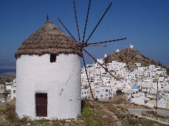
View on Chóra from the mills
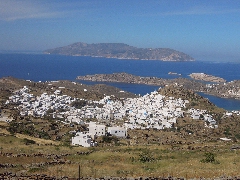
Panoramic view on Chóra and the bay of Ormos
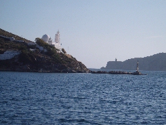
Agia Irini salutes
the ships at the entrance of the bay of Ormos
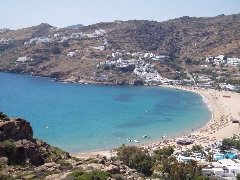
General view on the bay of Mylopótas
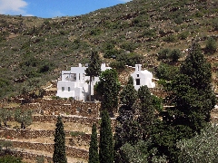
The little monastery of Agios Prokópios
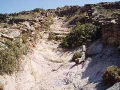
The monopáti to Agios Prokópios