|
Ioulída - Agios Theológos - Agios Nikólaos - Profítis Ilías - Ioulída |
||
| Evaluation:
This hike
follows the route of the walk
[9]. It
thus first
follows a gravel road,
then a very beautiful but very little known
path up to Agios
Nikólaos. Then
we must again follow
a gravel road,
then a stretch of the asphalt road,
until we reach
the wonderful path
of the walk [3]
that returns on the slopes of
the Profítis Ilías
until Ioulída.
Deserves ***. Estimated time: This walk takes, in actual walking time (AWT), just over 3 hours: it takes 50 minutes by a gravel road to reach Kalogerádos and 25 minutes to follow the beautiful path up to Agios Nikólaos. We then have to follow a gravel road, and then the asphalt road during 33 minutes, but thereafter we can follow during 1h15 really wonderful trails that take us to our starting point. Our total walking time (TWT) amounted to approximately 6 hours, from 11h to 17h, with a long pause in the oak forest on the slopes of Profítis Ilías. Route
description: (0h00) For all
hikes departing from Chóra you leave from the parking place (with bus
stop). You walk on the left of the small shop of Kianos, through the
picturesque arched passage (the stóa). In this way you arrive at a tiny
square, the Piátsa, with the outdoor terrace of the café/estiatório I
Piátsa. The small street on the left leads to the Kástro, but you take
a right, through a modern vault, to the centre. After some 20 metres you
keep to the right at a large wooden hiking sign; in front of you, you
can see the church with the red dome of the Agios Dimítrios. You pass
the nice bar + outdoor terrace En Levkoó and via the Odós A. Lazarídi it
takes you a few hundred metres to get to the central square, the "platía",
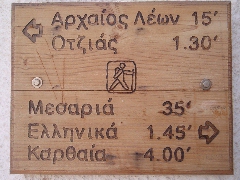
with the "dimarchío" or town hall. The hiking sign in Ioulída, at the beginning of walk [3]. (0h05) You thus take a right into the Odós Ilía Malavózou, which is a nice staircase street. After 14-15 steps you go up straight across and to the right [3] and further on you keep to the left [3]. After 77 steps you pass one of the three bakeries of Ioulída and later on there is a mini-market on the left – over here you might buy some more drinks or other supplies. The street continues to go up and by means of a small, climbing concrete road, it leaves the village after 4 minutes; on the left you have a nice view on the site of the Lion.
View on the site of the Lion and path [1]. Another 2-3 minutes later you pass a nice well; from here, the view on the location of the Lion and on the trail of hike no. [1], which runs past the cemetery, above the Lion and then further on, is the most beautiful. The following climb up is really steep and then you arrive at the asphalt road; the staircase continues on the opposite side (a sign points to Elliniká and Karthéa + [3]). You have now been hiking for 19 minutes (0h19) The beautiful path, which is, especially in the beginning, a broad and paved staircase, passes a few houses. Some 4-5 minutes later it gets to the little asphalt road, that runs over the hill crest with the mills, close to a chapel. Over here, there used to be 26 mills, mainly on the right, but also on the left – this is the largest number of mills anywhere on the Cyclades! You follow the road to the left, but some 50 metres further, between a house and the first of two mills, the old trail takes a right; in this way you pass on the right-hand side of the 2 mills. You thus avoid a part of the road, but a little later you do get to this road again, where you take a right. Further down, you go to the right again (there is a [9] on the wall).
[Some 10 metres on the left of this road you find the beginning of the
overgrown staircase, leading to the 512-metres high summit of the Thólos.] (0h25) You thus take a
right on the concrete road and you climb up a little. You then have a nice
view on the row of mills; you can count 13 of them, of which some have
been restored. The hill crest with the mills. About 3-4 minutes later you DO NOT go left, of course, but you proceed straight ahead. After a few more minutes you reach the highest point of the road (approximately 420 metres), with on the left a great view on the slopes of the Profítis Ilías, densely covered with oak trees. After a couple of more minutes you pass the (closed) chapel of Agios Ioánnis Theológos.

Agios Theológos. (0h35) Slightly further,
you can see a cart track on the left [9]
and you now walk steadily, usually going down slightly on the slope of
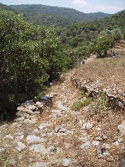
the valley full of oak trees. (0h48) Just past a recently built chapel, there is an obvious staircase going down on the left - there is a [9] on an oak tree. One minute later, you suddenly go left and you go down on a a wonderful trail that winds with nice steps down in the valley.
The marking of the beginning of trail [9].
The monopáti [9]. |
The shady path on your way to Agios Nikólaos. (1h04) The next part is really beautiful: you continue under the Mediterranean maple trees and between the flowering broom and swirls of butterflies, until you end up after again 8-9 minutes on a gravel road, which ends here next to some houses and the chapel of Agios Nikólaos. You go of course to the left. (1h13)
You now must follow
this gravel road for quite some
time, but the
walk is pleasant
enough because of the
green landscape, with
hills covered with oaks.
After some steep
turns, a section
of concrete and then again
a difficult climb,
you get, after 23-24 minutes
in total, on the asphalt road
that leads to
Káto Meriá.
The walk [3]
passes here and you take a left.
The splendid monopáti [3] on the slope of the Profítis Ilías. After
4-5 minutes the monopáti
leads to a gravel road
that you follow straight.
This trail ascends
quickly to the right,
towards the summit,
as you continue straight
ahead on the path [3],
which is always very well
paved. (1h51) After 2 minutes, a beautiful staircase begins and thereafter you follow the marvelously paved monopáti that descends slowly for many more minutes. You gradually veer to the right, on the slope of the Profitis Ilías, but after 6-7 minutes there is a sharp turn to the left. You descend for a few minutes and then you go up again during another 8 minutes – the path is always beautifully paved, a real work of art, an archaeological heritage that should be cherished!
The beautiful pavement of monopáti [3]. After 18 beautiful minutes, you reach a narrow gravel path, and in this way you arrive at the asphalt road, where you go right. 2h12) You thus follow the asphalt road for only 70 meters, and then you take a gravel road off the left (signpost Church Episkopí). Almost immediately there is a narrow path on the left (signpost Ioulída 40 'and [3]). You descend for 3-4 minutes on a nice rocky or paved path - sometimes between a mass of butterflies. After 4 minutes already you arrive at the important crossroads where the path to the right leads to Episkopí (and continues to Sikamiá), but you descend to the left, of course, in a side-valley. (2h17) You go down on a wonderful staircase and you soon reach the beautiful source of Messariá.
The well of Messariá. You curve to the right and a little further you
continue your descent to the right, into a small valley – and soon you
go up again on nice steps. (2h42) A little bit further your path takes a right, in a bend of the road to the left, and soon it becomes a nicely paved staircase. After another 5 minutes you get to the main road again, but a little concrete road descends straight ahead. (2h47) A few minutes later, next to a relatively modern source from 1952, you have a beautiful view over Ioulída and the kástro, and on the right over the site of the Lion. After a little over 7 minutes you get to the shop where you went left this morning, and of course you descend to the right – you now need about 8 minutes more to get to your starting point on the Piátsa. (3h02)
To
get the printer friendly version |
|
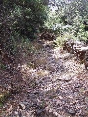
(0h51)
You do not continue into the
riverbed, where
there is still a trickle
of water (June
7, 2007), but you stay on the
right of the bed.
However, a little further,
you find yourselves still
in bed and
you follow it for about
9 minutes, continuing
without problems between walls.
Already after
6 minutes,
a faint trail goes
left,
but you continue straight
ahead in the bed that now is
rather large. [This path comes from Kalogerádos, see the walk Ioulída - Mýli - Kalogerádos - Ioulída.] |
||


