Ioulída - Lion - Dosonári - Diaséli - Otziás and back |
||
|
Evaluation:
This hike
will probably be the first hike you make on the island of Tziá. This is
a very nice hike, indeed, which continuously runs along marvellous
trails; you get to visit the famous Lion, you pass one of the nicest
wells and you then descend on really exceptional paths to the beautiful
bay of Otziás with a very pleasant beach. The hike is also very well
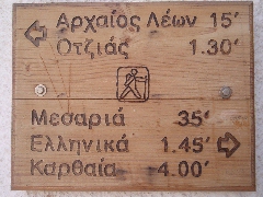
signposted, by means of wooden signs and red-white trail markers [1].
The way back proceeds along the same route, which gives you the chance
to discover the trails and the landscape from a different perspective.
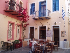
This hike deserves the maximum evaluation of ****. Route description: (0h00) For all hikes departing from Chóra you leave from the upper parking lot (with bus stop). You walk on the left of the small shop of Kianos, through the picturesque arched passage (the stóa). In this way you arrive at a tiny square, the Piátsa, with the outdoor terrace of the café/estiatório I Piátsa.
The Piátsa.
The small street on
the left leads to the Kástro (hiking sign [2]), but you take a right
(hiking sign for the hikes [1], [3], [4], [10] and [1]), through a
modern vault, to the centre. After some 20 metres you keep to the right:
in front of you, you can see the church with the red dome of the Agios
Dimítrios. You pass the nice bar + outdoor terrace En Levkoó and via the
Odós A. Lazarídi it takes you a few hundred metres to get to the central
square, the "platía", with the "dimarchío" or town hall.
The hiking sign for walks [1] and [3].
(0h06) The hiking sign points
straight ahead and in this
way it takes you 1-2 minutes to reach the large church of Agios
Spiridónas, with next to it the beautiful terrace of the restaurant To
Stéki.
View on the site of the lion of Kéa.
(0h12) Your path curves to
the left [1] and passes underneath the cemetery with picturesque cypress
trees; you thus get a nice view on the village of Chóra behind you. You
pass a nice well with the date 1928 and you get a nice view on the Lion
as well. Further on, the trail curves again to the left, near a well and
underneath the small chapel of Agios Elefthérios – a great spot to
admire the panoramic view of Chóra. The pavement comes to an end and two
minutes later you arrive at the small metal gate on the left that gives
entrance to the Lion of Kéa.
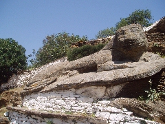
The lion of Kéa. This magnificent statue, dating from the years 600 BC, is a statue from the archaic era: the slight smile of the animal reminds us of the smile of the koúros-statues, so typical for the archaic era (7th – 6th centuries BC). The lion is probably connected to the legend of the lion that chased the nymphs. According to the myth, the bloom of the island, which was then rich in water (hence the ancient name "Hydroussa", from the ancient Greek "hudoor" = water) and which was the residence of the water nymphs or Naïades, was brutally disturbed by the arrival of a lion. The lion chased away the water nymphs, who fled to the nearby Euboea, which was followed by a long period of drought. This drought came to an end, only because Aristaeus, son of the god Apollo, and known as the inventor of the apiculture, brought into existence the summer wind or meltémi, and this as a result of his sacrifices to the god Zeus. Maybe, the smile we saw on the face of the lion, was rather a grin…?
The "grin" of the Lion. (0h20) After this mythological intermezzo you return to the main trail, which you continue to the left ([1] and also [10]); sometimes it is rocky and sometimes it consists of gravel.
The broad path between the Lion and the source of Venjamin. You have a nice
view on the left and behind you and after some 7 minutes you arrive at a
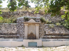
large spot near a marvellous plane tree and the beautiful well of
Venjamin (Benjamin) (hiking sign Otziás 1h20).
The source of Venjamin.
Taking notes next to the source of Venjamin...
(0h27)
Straight ahead, your
gravel path continues horizontally and some 2 minutes later you arrive
at a junction with a sign post: going down on the left is your trail
[1], which continues to Otziás, the trail on the right leads to Spathí
[10] – see the walk Ioulída – Lion – Agios Dimítrios – Spathí.
(0h29)
You thus take a left: the monopáti is now nicely paved and it descends
into the valley under the form of a beautiful staircase. After 10 very
nice minutes you describe some nice turns.
The splendid monopáti to Otziás.
(0h38)
After a beautiful descent you reach a stretch that is flatter; you pass
under some beautiful trees and you cross a dry river bed [1] -
sometimes, there are many little grasshoppers at this spot. These
grasshoppers are really special because of their double wings when they
fly. Also the oak trees are striking - they are very typical for the
inland of Kea. The narrow path now goes up, along beautiful almond
orchards and oak trees. You pass a recent well (1960) [1] and shortly
thereafter you reach a broad gravel road. (0h48) Pay attention: you follow this road only 1 minute to the left (wooden hiking sign and [1] on a pole), but soon the path continues to the right (sign and [1]): it is pleasant to walk on the path that gently goes downward, midst a lot of flowering broom (May 26, 2006) or the graceful cyclamen (September 23, 2009).
Some nice details along the path to Otziás. |
After 7-8 minutes
you arrive at a very shady, cool spot under Mediterranean maples; you
then descend on a steeper, rocky or paved path into the bed of a river.
You follow the river bed to the left, during a few minutes, until the
path leaves the valley to the right [1].
The path passes between strange rock formations. (1h08) You continue to descend and get some nice views of the entire valley – all the way to the sea. After 2 minutes you arrive between walls and you see how the path continues nicely on the right-hand slope of the valley.
The path now continues on the right slope of a deep valley.
Further on, you get
to a wonderful, almost flat stretch, with obvious curbs on the left-hand
side; you go higher and higher above the valley that gets wider. After
13 easy minutes you arrive at a ridge with some houses and then you
reach 2 roads.
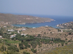
Panoramic view on the bay of Otziás.
You take a left,
obviously (sign and [1]), but almost immediately your path continues
diagonally to the right (white arrow, red dot and [1]). At this point
you can enjoy a magnificent view of Otziás, your final destination.
(1h24)
The descent that follows is quite easy. After 7-8 minutes, while
arriving at the first houses, the path gets sloppy because of the
rubbish that proves that "civilization" is nearby. After a total of 12
minutes you arrive at a gravel road, which you follow straight ahead. A
little further you keep to the left on a concrete road and after a short
time you reach the main asphalt road – you take a right here [1].
(1h38)
Pay attention now: already after 30 meters, there is a path that goes
down to the left, next to three little white poles (hiking sign and 3 X
[1]). At first the stony and sometimes worn away path descends quickly,
but later on it continues as a wide, grassy path between walls, straight
to the sea.
The sandy beach is
nice and wide, with umbrellas, sheds and benches. It is better to
continue another 100 meters to the right, where the beach is better,
because of the shade of tamarisks. To the right, beyond the asphalt
road, there is also the nice tavern Otziás with a beautiful outdoor
terrace.
The beach of Otziás. (1h50)
In order to start your way back you walk along the beach, and 50 meters before
the end of it, you go left into the sandy river bed (sign Ioulída 1h40). You
cross a little road and you continue straight across ([1] on a wall). After a
little over three minutes you leave this bed diagonally to the right, in order
to follow a little road between walls, at the right-hand side of a gate [1].
This is a beautiful, grassy little road, which goes up to the asphalt road.
(2h01)
You take a right, but in the curve, some 20 meters further, and next to a tiny
blue chapel, you go up to the left on a little concrete road [1]. After another
20 meters you find the path between walls on the right-hand side [1], and a
little bit further you continue of course to the left of the wall and the gate
[1]. (2h14) You now enter the beautiful valley on a marvelous path that you see continuing far away in front of you – it is flat or rises slightly – sometimes, it is narrow because of the vegetation, but later on, it becomes very nice, with splendid border stones.
During your way back, above the beautiful valley - and the splendid path.
After 13 minutes, you reach the upper part of the
valley, but the climb gets even steeper on a path paved with large stones. You
pass under a large rock and you continue to climb on nice steps. After 16
beautiful minutes you arrive in the rocky bed of a river and you cross this bed. (2h30) The path goes straight ahead, but soon you arrive in the bed of a side valley; after a little over one minute, you leave it to the right, but you return to it. Later on, you keep to the left [1] and leave the bed, again to the right [1]. You get now to a beautiful staircase and a nice climb.
A nice staircase, and ... an obstacle...
After some minutes, the climb becomes less steep and you arrive at a
dirt road (2 wooden hiking signs). To the right, you already see the
mills above Ioulída. (2h44)
You go left (sign and [1]) and after 40-50 meters you take a right (sign and
[1]). First, you follow a stony path that descends slowly, and after 3 minutes
you cross a small river and you curve to the right [1]. You go up slowly now, on
a beautiful path, at first next to some nice oak trees, further on next to
almond trees.
(2h53)
After another 6 minutes you come to a beautiful, fairly recently paved
staircase; you follow this bright white staircase for over 11 minutes!
A marvellous staircase! (3h04) You then arrive at the junction with the path that comes from Spathí, where you go straight [1] and after a little over one minute you reach the Venjamin source. Here the trail becomes wide and it continues horizontally (sign “Lion of Kéa”): it bends to the left and you get a nice view of Ioulída.
Just past the source of Venjamin - Ioulída appears in front of you. Your path now runs next to the site of the Lion and then it bends to the right – in this way you walk around the entire valley. The path stays obvious, also in Ioulída: you always go straight and in this way you arrive at your point of departure without any problem. (3h30)
Gpx-files:
To
get the printer friendly version |
|
