|
Ioulída - Episkopí - Tría Maderiká - Sykamiá and back |
||
|
Evaluation:
This hike combines the beginning of the official hike [3] with hike [4],
which actually leaves from Episkopí. A few parts of the monopáti,
especially between Episkopí and Tría Maderiká, belong to the most
beautiful trails of the island. After the descent, you can have a great
swim on the usually deserted beach of Sykamiá.
Estimated time: The way there of this hike
(7,82 km)
takes 2h50, in actual walking time (AWT). If
you would like to return on foot – with a difficult climb in the
beginning -, this will turn out to be a long hiking day, so you better
start early in the morning. Indeed, the way back takes the same time,
about 2h50 - so the total actual walking time rises up until about 5h40.
As usual, the total time (TWT) can mount up to nearly the double of the
actual walking time.
Route directions: (0h00) For
all hikes departing
from Chóra you leave from the upper parking lot (with bus stop). You
walk on the left of the small shop of Kianos, through the picturesque
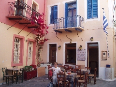
arched passage (the stóa). In this way you arrive at a tiny square, the
Piátsa, with the outdoor terrace of the café/estiatório I Piátsa. The Piátsa.
The stóa that leads to the Piátsa.
The small street on
the left leads to the Kástro (hiking sign [2]), but you take a right
(hiking sign for the hikes [1], [3], [4], [10] and [1]), through a
modern vault, to the centre. After some 20 metres you keep to the right:
in front of you, you can see the church with the red dome of the Agios
Dimítrios. You pass the nice bar + outdoor terrace En Levkoó and via the
Odós A. Lazarídi it takes you a few hundred metres to get to the central
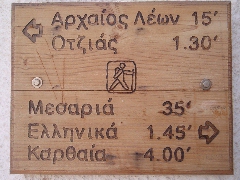
square, the "platía", with the "dimarchío" or town hall. The hiking sign in Ioulída, at the beginning of walk [3]. (0h06) You thus take a right into the Odós Ilía Malavózou, which is a nice staircase street. After 14-15 steps you go up straight across and to the right [3] and further on you keep to the left [3]. After 77 steps you pass a chapel [3]: the street continues to go up and by means of a small, climbing concrete road, you leave the village after 4 minutes; on the left you have a nice view on the site of the Lion.
View on the site of the Lion and path [1].
Another 2-3 minutes later you pass a nice well + washing-place; from
here, the view on the location of the Lion and on the trail of hike [1],
which runs past the cemetery, above the Lion and then further on, is the
most beautiful. The following climb up is really steep and then you
arrive at the asphalt road; the staircase continues on the opposite side
[3].
(0h19)
The beautiful path,
which is in the beginning a broad and paved staircase, later on an rocky
path and a little road, passes a few houses. Some 4-5 minutes later it
gets to a little asphalt road, where you go diagonally to the left and
you arrive at the asphalt road after about one minute.
(0h27)
A gravel road continues straight across ( [3] on the left-hand wall).
Almost immediately, the monopáti continues on the right [3], and it is
nicely paved now and then. After another 5 minutes, at a tall
electricity pole, there is a junction: trail [3] continues on the left.
The path is now narrow and
stony and it descends gradually for about 3 minutes; it then continues
as a grassy and flat monopati [3], dug in between walls. (0h38) At a bifurcation, the trail goes up to the left [3], but past some ruins, it goes down again; you reach in this way a road that ends here [3]: you take a left for a short while, but immediately, you take a sharp right [3]. The beautiful path descends between walls for about 4 minutes, it goes up again and it arrives at a wonderful well with clear, potable water - the sign indicates the year 1879.
The well in Messariá.
(0h47) You take the nice
staircase going up on the left and after 2 minutes already, you reach a
clear three-forked junction, where the hikes [3] and [4] split: walk [3]
continues up on the right, and straight ahead your walk [4] continues to
Sykamiá. (0h49) You thus keep a bit to the left ([4] and blue dot) and some 2-3 minutes later you get to a well-indicated side-road (hiking sign): this is the path to Episkopí.
The beginning of the path to Episkopí.
You now will make a slight detour and follow this path to the right; you
reach in this way a gravel road, which you follow to the left and then
to the right.
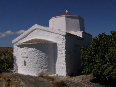
The site of Episkopí.
The beautiful church of Episkopí, with some ancient elements in the wall. You retrace your steps:
you thus go down on the concrete slope, you take the gravel road on the
left and then the path on the right (sign and [4]) - and you get to the
main path of the walk [4].
There, you take of course a right.]
The path just past Episkopí.
The cobwebs over the trail tell you that it is not often used by hikers...
After 3 minutes, you reach some ruins and walls, and in front of you
lies a deep valley. You should NOT descend to the left, but you must
turn right - a mark [4] and a clear blue arrow show the right direction.
The trail is now obvious and continuously flat and continues grassy
under the shade of trees. After another 5 minutes, you pass a house, and
2 minutes later, you pass to the left of another house (little gate)
over a short stretch of gravel - you go down on a paved staircase
towards a concrete road that you follow a short time - but, fortunately,
this road becomes, after again one minute, a beautiful trail [4], to the
left of that road.
(1h38)
You follow this gravel road for 5-6 minutes, then you reach the asphalt
road, next to a metallurgical plant. You are still at an altitude of 440
meters ...
A marvellous path!
After a quarter of an hour, you you reach a rocky terrain between walls
([4] and blue mark). The bended trees... |
(2h11) A few minutes later you pass the source Tría Maderiká (with the date 1955) and you continue to follow the rising wall on your left, you follow this wall yet when there are few vague bifurcations. Then, suddenly, you see in front of you the bay of Sykamiá.
During the walk to the bay of Sykamiá.
(2h16) You come to the right
of another low wall, near a mark [4] on a triangular rock, and later,
you continue again to the right of the first wall. You veer right onto
the vague path, but you see already to the left and below the two walls
on the rocky ridge, between which you will go down. So you come against
a high wall and you veer left ([4] and blue mark). The descent is steep
and follows tight turns, and twice you get between narrow walls.
(2h27)
You pass a lonely tree and the ridge becomes very narrow: you already
see the beach and the following steep descent. The monopáti to Sykamiá.
(2h37) You step over the low
wall to the left ([4] and blue mark) and you continue now on a very
vague trail, which winds down - this trail descends first more or less
towards the beach, but then you veer to the right, so that you arrive
after 2 minutes against a wall. You go left and so you zigzag toward the
left side of the slope, while following the many signs [4] and blue
marks. The descent to the bay. The water is amazingly clear, but quite cold until early June - because of the bay that opens out to sea. The beautiful beach is shaded by some large tamarisk and some umbrellas.
The beach of Sykamiá.
[If you do not want to walk back, you need to call a taxi - if he is
willing to drive down the bad gravel road to the beach, there are no
problems. The taxi will cost about € 20 (May 2006).
Just make some notes...
Here you can enjoy a beautiful view over the sea, with to the left the
vague form of Andros, then Giáros and to the right Kýthnos, with behind
it Sérifos and Sífnos.
A truly idyllic landscape.
(4h16) You get to the asphalt
road, next to the tank, and you take the dirt road, in front of you and
a little to the right, right of the metallurgic plant ([4] and sign "Episkopí").
After 3-4 minutes, there is a fork where you hold left [4], and the
trail starts a little farther, diagonally to the right [4].
The path is always very obvious...
(4h36) You pass the path going
down to the source of Sotíras (sign) and you mount straight ahead. The
climb continues under the trees until the trail becomes a small concrete
road. You follow it only one minute, because a little further, you can
take concrete or paved steps to the right [4]. You pass a house and you
find again a nice and flat trail. Further, you see suddenly the height
of Episkopí and your very green trail, which is sometimes overgrown, now
continues to the right of this height. Shortly after, there is a path
that comes from the right side: you go left [4] and continue again under
beautiful trees. Between Sotíras and Episkopí, a beautiful stretch!
A little further, you pass the path leading to Episkopí and two minutes
later, you arrive at the junction with the trail [3]. (4h54) You go right of course and then down on a wonderful staircase and you soon reach the beautiful source of Messariá.
The well of Messariá.
You curve to the right and a little further you continue your descent to
the right, into a small valley – and soon you go up again on nice steps.
(5h12)
You now follow another beautiful and nicely paved stretch, and then you
go up to a little asphalt road. You arrive at this road after again 4
minutes, and you keep to the left. You soon reach the main road, where
you follow the little asphalt road straight ahead ([3] and signpost Ag.
Paraskeví / Míli).
(5h20)
A little bit further your path continues obliquely to the right, to the
left of a small ruin, and soon it becomes a nicely paved staircase.
After another 5 minutes you get to the main road again, but a little
concrete road descends straight ahead.
(5h28)
A few minutes later, next to a relatively modern source from 1952, you
have a beautiful view over Ioulída and the kástro, and on the right over
the site of the Lion. After a little over 6 minutes, the steps begin and
you descend always straight ahead; after 91 steps, you get to the main
street, where you take a left of course in order to return to your
starting point on the Piátsa. (5h42)
Gpx-files:
In
order to get the printer-friendly version |
|