|
Evaluation:
This circular hike
has recently been marked with trail markers [10] and runs through the
lonely interior of Sérifos, northeast of Kallítsos.
From the chapel of Profítis Ilías, one can possibly make a detour to the big
monastery of Taxiárches.
[6th of October 2015.]
[The
translation of this walk was
made with some help of Google translate - so, please, do not mind the
mistakes...]
Estimated
time:
It takes about 40
minutes in actual walking time to get to the chapel of Profítis Ilías
and 40 minutes until Triantáfyllos.
The return to Kallítsos through the Panagía Skopianí lasts for 1 hour -
the actual time (AWT) thus amounts to a total of 2h20.
We walked from 10.30am until 3.30pm, a total time (TWT) thus of 5 hours.
Route description:
[You start the walk
on the asphalt road near Kallítsos and you cross the village towards the
beginning of the route of walk [10].
There is a bus up to Kallítsos, but you have of course more time, if you
come by car or motorbike: you can leave the car just before the village
(near the sign "Kallítsos") if you come from the direction of Agios
Ioannis, just after the village if you come from the direction of Galaní
and the monastery.]
(0h00) You leave from the
asphalt road near the sign "Kallítsos” and
you go down the
brick staircase on the right (2 red dots + [1]) – this staircase gets
down to the old trajectory of hike
[1].
You enter the
village by taking a sharp left and you continue going down the staircase
towards the ‘centre’;
you get to a cross street where you take a left, and a little further,
you keep to the left again: so you will finally get to a kind of square.
Over there you find a tap where you can freshen -
this is a lovely spot,
underneath some palm trees and pines, isolated and peaceful.
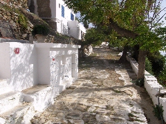
The "platía" in
Kallítsos.
(0h04)
You continue
straight, then you take the nice staircase that rises to the left; you
veer to the right and you reach a wide paved street that leaves the
village while going up. The street becomes a concrete road and at the
top, next to the very last house, a dirt road. After a minute, you still
arrive on concrete, you go up to some ruins, you veer left and you get
to the actual route of walk [10].
(0h12) Now you go up to the
left on a concrete road (signs). You cross the asphalt road after 1
minute and continue straight across (red sign Profítis Ilías 35
minutes).

Hiking signs and an
information panel for walk [10].
After 4-5 steps, you keep to the right between stables (=)
following a very uneven rocky path: it rises to the right of a wall and
then for quite some time between walls. You have a beautiful view of Kallítsos and you arrive after about 8 minutes next to a large round
ruin.
(0h21) You veer slightly to
the left (=) between the walls and you still go up a bit until you get
to a slight depression between your hill and the next one - on the
right, you enjoy a nice panorama on Kýthnos and on the islets of Vous
and Pipéri. You continue flatly for some moments, but at the end of the
depression, you do NOT go up to the right between walls, but you veer
left (=) in order to follow a clear path towards a grove and a small
building. After an easy end, you go up again, always with a beautiful
view of Kallítsos and the bay of Kéndarchos. About 5-6 minutes later you
descend slightly to the left (=) and you reach an easy path that
continues between rocks and ruins until a cross valley.
(0h35) The small sign [10]
points straight ahead and you go up while winding between ruins and
rocks (=), on a rocky slope or on rocky steps. You thus arrive after 4
minutes between a wall and a nice grove of oak trees and so you get to a
gravel road (red sign [10]).
(0h41) You take a right and
soon you veer to the right – with
Galaní to the left and in front of you the chapel of Profítis
Ilías – and then left again (sign [10] and =). You pass beneath a rather
elegant building with a dovecot and you finally arrive near the small
nice chapel of Profítis Ilías - it is closed.
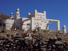
A strange building with a docevot...
[The
gravel road that turns left leads to the monastery - see the hike Chóra
- Stavrós - Kallítsos - Moní Taxiárchoon and back.
It is a detour of a little over 20 minutes for the way out or the return...]

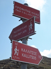
The chapel of Profítis Ilías and the hiking
signs for walk [10]. |
|
(0h49)
Today, you go to the
far RIGHT in order to follow a narrow path along a metal fence (=).
You arrive between walls, you slowly veer to the right - the trail becomes
narrow between the fence and the wall - and then you start going down
rapidly, always with the wall on your right.
(0h56) You come again between
walls, you pass a source on the right, and after an easier stretch, you
still go down very quickly on a path that was cleared recently (=) and
with the monastery on the left in
front of you.
The walls diverge, you pass a brownish ruin and, towards the end of this
difficult descent, you veer slightly left and right, while carefully
following the signs = =.
You still go right and you thus arrive above the asphalt road, where you
continue towards a small post.
(1h07)
You finally get to the asphalt road (red sign): you take a right for two
minutes, but near another red sign, you go down to the left on a narrow
path.
You zigzag to the left in the direction of a post, where you go right (red
sign).
You still go down, but at the end of a wall surrounding a house, you veer
right (= on a stone): you always stay between a fence and a wall that
converge, straight to the nice small bay of Platýs Gialós.

The little bay of Platýs Gialós.
(1h14) You climb down to a
road where you go left [10];
you still veer left, then you turn to the far right onto a small gravel road:
it descends in 8 minutes until Triantáfyllos (signs).
(1h22) Here, the road
describes a sharp turn right, then left - you have for a moment a good
view of Platýs Gialós - and your road then winds down and right, into a
very green valley.
It comes to a dead end after 4 minutes, but there is a path that keeps
going down on rocks (=) and next to some reeds.
You pass a pumping station, you cross a river bed and you climb again,
first on a few steps, then passing a pole that lies across the path.
You go up to the left, first next to and then between some rocks, along a very
rocky and stony path that rises quickly.
(1h34) Pay attention: when
you come on more open ground with pale rocks to the right and in front
of you, the trail apparently continues, but you should take a sharp
RIGHT between two rocks and under a beam (=),
then you keep a little to the left on the slope, straight south (=).
You follow the signs = = on the pale rocks and you arrive after a few
minutes on a narrow ridge between two valleys.
This ridge becomes even more narrow further on, with a narrow path between
walls, and you go up in this way to the left of a beautiful oak wood -
an ideal place to take some rest or picnic.
(1h45) You go up between a
ruin (=) and a lovely row of trees, and above, you veer left following
the left wall;
you pass a small white building and you get to a small dirt road (=).
Just before this road leads to a wider dirt road there is a path that you can
follow to the left (=), which later however still gets to that road.
(1h50) You follow the road to
the left (red sign), but a minute later, you can go up to the left (red
signs) in order to make a detour of about 100 meters until the Panagía
Skopianí: the chapel is closed, but
there are 2 large terraces with a beautiful view of Platýs Gialós.

Panagía Skopianí.
You retrace your steps, but once arrived in the turn of the concrete
road, you continue straight (sign and =).
A nice easy trail brings you after 4 minutes under and beside three oaks,
inclined due to the wind.
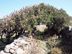
Inclined trees...
After a nice stretch, you come on open ground, with little roads to the
right, to the left and straight ahead: you continue straight ahead (red
sign), between a fence and a wall (=).
Still 4 minutes later, you arrive on concrete next to a ruin.
(2h06) Walk [10] goes up to
the right here, towards the asphalt road, but you take a LEFT along the
concrete road that returns to Kallítsos. The concrete or gravel road
becomes paved and finally descends like a staircase that winds left and
right, to the small “square” with the source and the trees ([1] on a
pole).
You continue straight ahead (red sign Chóra 1h40): you first veer left,
but near the bifurcation you go right and at the 1st or 2nd street, you
go up to the right again [1]. You always go up and up, but at the end of
the stairs, you take a sharp right on the paved staircase [1] and you
get to the asphalt road.
[Just opposite a red sign "Chóra 1h35 / 4,2 km" points to the left;
a
little further, trail [1] starts to the right...]
To
get the printer-friendly version
with only the text
in one column
click here. |


