2012, 2015, 2018, 2022 and 2024
Walking, hiking and trekking on KEA or TZIA
WALKS
(last update on the 17th of January 2024)
*** = very beautiful
**** = exceptional
+ Gpx = with Gpx-file
1. Agios Simeoón - Agios Fílippos and back *** + Gpx
2. Agios Simeoón - Karthéa and back **** + Gpx
4. Ioulída - Agios Konstantínos - Mylopótamos - Fléa - Agia Marína - Plagiá - Písses ***
5. Ioulída - Agios Konstantínos - Mylopótamos - Fléa - Korissía + Gpx
6. Ioulída - Agios Theológos - Agios Nikólaos - Profítis Ilías - Ioulída ***
7.Ioulída and surroundings ***
8. Ioulída - Episkopí - Tría Maderiká - Sykamiá and back **** + Gpx
9. Ioulída - Lion - Agii Theódori - Sorós - Kastrianí
10. Ioulída - Lion - Agios Dimítrios - Spathí and back ***
11. Ioulída - Lion - Dosonári - Diaséli - Otziás and back **** + Gpx
12 Ioulída - Messariá - Episkopí - Profítis Ilías and back **** + Gpx
13. Ioúlida - Messariá - Profítis Ilías - Astrá - Elliniká - Agios Simeoón - Karthéa *** + Gpx
14. Ioulída - Mýli - Kalogerádos - Ioulída ***
15. Ioulída -
Mýli - Petrovoúni - Sklavonikóla - Agia Marína and back
16.
Ioulída - Mýli - Petrovoúni - Skalovonikóla - Agia Marína - Plagiá - Písses
*** + Gpx
17. Ioulída -
Mýli - Thólos - Kalogerádos - Ioulída
18. Ioulída - Roúkounas - Kómi - Agios Konstantínos - Mylopótamos and back ***
19. Karthéa - Vathypótamos - Kalódouka - Káto Meriá ***
20. Karthéa - Vathipótamos - Stavroudáki ***
21. Mylopótamos - Fléa - Agia Marína - Plagiá - Písses and back ***
22. Stavroudáki - Vathypótamos -
Karthéa and back *** + Gpx
Kéa has a surface area of 131 km², which means that, apart from the island of Milos, it is the largest of the western Cyclades, and the sixth largest of all of the Cycladic isles, after Náxos, Andros, Páros, Tínos and Mílos: it is about 19 km long and never wider than 10 km.
There are about 1800 people living on Kéa, of which 600 live in the town of Chóra or Ioulída and 350 in the small harbour of Korissía; the rest of the people are spread over some 30 small villages and hamlets.
Kéa has a mountainous relief, with summits often higher than 500 metres: the highest point of the island is the Profítis Ilías (568m). As a result of the intense erosion the mountainous island is criss-crossed with deep valleys, such as the valleys of Spathí, Agios Fílippos and Póles (Karthéa) in the east and Písses in the west. In the coastal region there is not really a lot of overgrowth, just like on the other Cycladic isles, but the interior is fertile and green, amongst others because of fruit trees and because of a lot of oak trees (valinídhies or quercus aegilops).
The island has a couple of beautiful beaches, like the beaches of Otziás or Vourkári in the north or the beaches of Písses and Koúndouros in the west – especially at those places there is a lot of tourist infrastructure. On the other side, there are also some small bays and often deserted beaches, which you can sometimes only reach on foot, such as the bays of Spathí, Sikamiá, Agios Fílippos and Póles (Karthéa) on the east coast.
The main town of Chóra or Ioulída is situated in a mountainous area, which means that the picturesque little town has a lot of relief – there are also plenty of staircase-streets. Chóra is dominated by the Kástro with remnants of the ancient akrópolis, and on the southern side by the rests of a lot of wind mills. The little town has also an interesting archaeological museum and nearby you can visit the famous Lion of Ioulída, a unique archaic statue dating from 600 BC.
Kéa has a glorious
history, with the first traces of organised life already in the 4th
millennium BC. From the archaic times onwards the antique island of Kéa
had 4 autonomous cities (it was a "tetrapolis"), with the
harbour Korissía, Ioulída (around the Kástro), Piiéssa (the present
day Písses) and Karthéa. Especially the remnants of the temples of
Apollo and Athena in Karthéa are still very interesting. The famous poets
Simonides and Bacchylides were also from Ioulída.
After the Byzantine
times, Kéa was conquered by the Venetians in 1207: the Venetian name Zia
later led to the name Tziá, which nowadays is the name of the island
mostly used by the Greeks. In 1537 the island became Turkish, but this did
not prohibit the relative bloom of the island, which in 1780 counted about
5000 inhabitants. Later on, and mainly after the Second World War, there
was a gradual depopulation, also because of the loss of traditional
agriculture; as a result, the island now only has about 1800 inhabitants.
Since the island can
mainly be reached from the smaller harbour of Lávrio (there is a bus
connection between Lávrio and the airport, going via Markópoulo), Kéa
lies away from the main boat lines – so also away from the tourist
stream. Mainly in spring and in autumn the island is very quiet, but
during the school holidays and also during the weekends Kéa is a
favourite destination for people from Athens – who are looking for peace
and nature.
Also the fact that many inhabitants only speak Greek shows that there are
not a lot of foreign tourists coming to Kéa – many of the signs and
inscriptions are often only in Greek as well.
Off season there are no busses either, so you often have to depend on
taxi’s.
As said, most of the
hotels and rooms are to be found along the coast, in places such as Otziás,
Korissía, Písses and Koúndouros; in Ioulída itself it is quite
difficult to find accommodation.
Still, staying in Ioulída seems to be the most attractive - this is the
best way to get to know this authentic little town. In any case, you
should try to stay in Ioulída for at least one evening, after the narrow
streets awake from their siesta; dining in restaurant "To Stéki"
is really a must!
Kéa has a well
preserved network of old trails and the island itself has put in great
effort to signpost these trails with wooden signs and the well-known
little red-white signs. There are a couple of publications you can buy on
the island; in these publications and on a number of maps the hikes are
numbered from [1] to [9]. The most beautiful of these are no. [1] via the
Lion to Otziás, the long hike no. [3] to Karthéa, hike no. [4]
to the beach of Sikamiá and the short hike no. [6] from Karthéa to
Stavroudáki.
Since most of these hikes depart from Ioulída, it is interesting to try
and find a room in the main town, although this is fairly difficult.
Since the year 2006
there exists a very good hiking map of Tziá or Kéa, in the series of Anávasi.
On the back of this map there are some extra explanations on the numbered
trails – as usual this is an indispensable tool for the hiker. However,
a number of gravel roads are not mentioned on this map (amongst others in
the regions of Kalogerádos and of the Péra Meriá) which makes it
difficult to follow hikes no. [9] and [4].
In the course of spring 2009 another map of Kéa appeared, now in the
series of Terrain Maps: this map is also very detailed and even more
precise than the Anávasi-map, but a few paths don't appear on the map,
such as the path from Fléa via Agia Marína to Písses and the recent
paths from Ioulída to Agios Konstantínos and from Slavonikóla to Agia
Marína.
There is also a map in the
series of Road, but this map does not contain a lot of indications of
monopátia.
The following hikes
are really a must:
1. Ioulída - Lion -
Diaséli – beach of Otziás (and back) (well indicated with no. [1])
2. Ioulída - Profítis Ilías - Elliniká - Agios Simeoón - Karthéa (well
indicated with no. [3], you can also divide this hike in two) or Agios
Simeoón - Karthéa and back
3. Ioulída - Episkopí - Péra Meriá - Sikamiá (fairly good indicated
with no. [3] to Episkopí, and then with no. [4])
4. Karthéa - Vathipótamos - Stavroudáki (fairly good indicated with no.
[6])
5. Agios Simeoón - Agios Fílippos (infrequent indications with
no. [8]).
Since January the 1st 2004
you are visitor n°

Panoramic view of
Ioulída
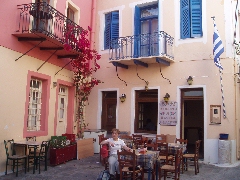
The piátsa in
Ioulída
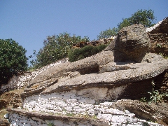
The Lióntas or Lion (600 B.C.)
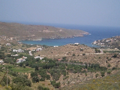
The beautiful bay of Otziás
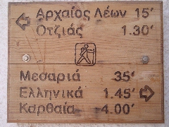
A signpost for walkers
in Ioulída
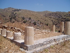
Ruins of the temple of Athena in Karthéa
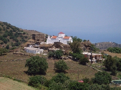
The old monastery of Episkopí
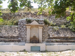
The source of
Vénjamin on Kéa
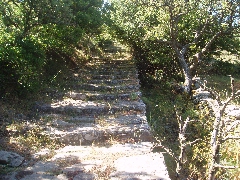
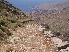
The nice monopáti of walk [3]
in the neighbourhood of the Profítis Ilías
The beautiful path of walk [3] to Karthéa