2010, 2012, 2014, 2017 and
2022
Walking, hiking and trekking on KYTHNOS
WALKS
(last update on the 20th of January 2022)
*** = very beautiful
**** = exceptional
+ Gpx = with Gpx-file
1. Chóra
- Agios Stéfanos and back *** + Gpx
2. Chóra - Agios Trýfonas - Trýpios - Diaséla - Vryókastro and back *** + Gpx
3. Chóra - Christós - Apókrousi
- Kolóna - Apókrousi *** + Gpx
4. Chóra - Kolofoniá - Apókrousi - Kolónna and back
5. Chóra - Loutrá and back + Gpx
6. Chóra - Panagía tou Níkous - Panagía - Agios Geórgios - Agios Ioánnis and back **** + Gpx
7. Chóra - Panagía tou Níkous - Agios Stéfanos ***
8. Chóra - Profitis Ilias and back ***
9. Dryopída - Agios Konstantínos - Episkopí - Dryopída
10. Dryopída - Léfkes and back *** + Gpx
11. Dryopída - Mathiá - Kaló Livádi - Antónides - Kanála
***
12. Dryopída - Panagía tou
Mathiá - Kaló Livádi and back *** + Gpx
13. Episkopí - Diasélla - Apokroúsi - Kolónna and back *** + Gpx
14. Episkopí - Dryopída and back
15. Kanála - Agios Konstantínos - Flamboúria and back ***
In addition, there are fairly frequent connections with the harbour of Lávrio, via Kéa; the Artemis also takes care of connections with Kéa and Lávrio, but also with many other Cycladic islands.
You reach the port of Mérichas at Kýthnos after a boat trip of approximately two hours and a half.
The surface area of Kýthnos is 99 km² and it has a population of about 1600 people.
Kýthnos is a rather
dry and arid island; some villages are really nice, especially Chóra or
Messariá
and Dryopída. There are majestic coastlines and beautiful beaches to seduce the
tourists.
Mérichas is a picturesque fishing port with some cosy hotels and restaurants. There are busses between Mérichas and on the one hand Chóra and Loutrá, and on the other hand Dryopída and Kanála.
Chóra is situated at about 5 km from Mérichas and it provides for some nice walks. It is really pleasant to walk in the streets, decorated with white floor paintings with little flowers and ships.
In Loutrá, even further to the north, you can find wells containing sulphur and iron.
Dryopída,
4,5 km south of Mérichas is impressive because a deep valley divides the
village in two neighbourhoods. Another 5 km further to the south lies Kanála,
with a church in the middle of a beautiful pine forest.
There are a lot of marvellous beaches at Kýthnos: slightly north of Mérichas there is the beach of Martinákia; and a little more to the north you find the magnificent beaches of Episkopí and Apókrousi, and the picturesque peninsula of Kolónna. Interesting as well are a couple of beaches that are not that well known, such as Agios Stéfanos, Agios Ioánnis or Kaló Livádi on the east coast, Flambouriá and Agios Dimítrios on the west coast.
The fact that Kýthnos does not easily reveal its attractions was, until recently, also due to the lack of decent hiking maps. But since a couple of years, there are two good maps, both in the Anávasi-series and in the series of Terrain Maps.
In 2016, an excellent little booklet was published, "Kythnos, hiking guide": it gives the 9 hikes which will be signposted in the future, together with nice photographs and good little maps. But in reality, the situation is not that good: only three hikes are well signposted for the moment - hikes [1], [4] and [5] - and some stretches of the walks are overgrown. This is e.g. the case (in 2017) with the beginning of hike [5] and even with some parts of hike [1] to the Kástro.
In conclusion, you can really make a lot of beautiful hikes on Kýthnos
- at the back of the Terrrain map you find 13 suggestions for
hikes; on this site we will eventually describe 17
hikes, of which the most beautiful are: the hike Loutrá to the Paleókastro, from Chóra to Agios
Stéfanos, from Chóra to the Vryókastro and especially from Chóra to Agios Ioánnis.
Since January the 1st 2004
you are visitor n°
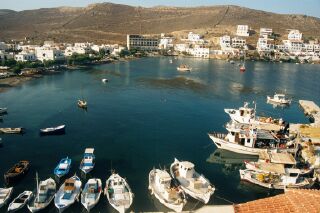
The fishing port of Mérichas
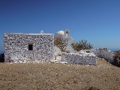
The monastery above
on the Profítis Ilías
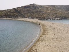
The sand tongue of Kolónna
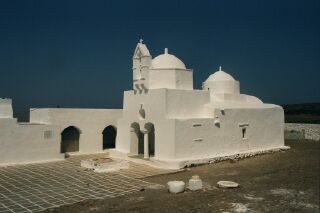
The church of Panagía Nikous, outside of Chóra
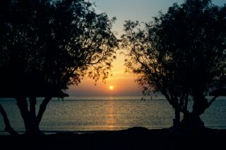
Sunset on the beach of Episkopí