KAART METHANA - CARTE METHANA - MAP OF METHANA
|
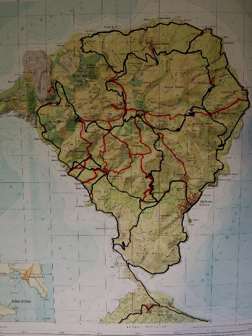
Deze kaart is gemaakt op basis van de topografische kaart 1/25 000 van de "Stiftung Vulkaninstitut Immanuel Friedländer" en het "Institute of Cartography" bij het "Swiss Federal Institute of Technology", met steun van Tobias Schorr - Wabern (Zwitserland), 1991 - 1994. Aangezien deze kaart gemaakt werd vóór de aanleg van enkele belangrijke asfaltwegen, zijn deze toegevoegd op basis van Google Earth. De zwarte lijnen zijn de belangrijkste asfaltwegen, de rode lijnen zijn de reeds beschreven paden [1] tot [9]. |
Cette carte a été reconstituée sur base de
la carte topographique 1/25 000 de la "Stiftung Vulkaninstitut Immanuel Friedländer" et de l' "Institute of Cartography" par le "Swiss Federal Institute of Technology", avec le support de Tobias Schorr - Wabern (Suisse), 1991 - 1994. Puisque cette carte a été faite avant la construction de quelques routes asphaltées importantes, nous les avons "ajoutées" sur base de Google Earth. Les lignes noires sont les routes asphaltées, les lignes rouges les sentiers de [1] à [9]. |
This map
is based on the topographic
map
1/25 000 of
the "Stiftung
Vulkaninstitut Immanuel
Friedländer" and
the "Institute of
Cartography" by the "Swiss
Federal Institute of Technology",
with the support
of Tobias Schorr
- Wabern
(Switzerland), 1991-1994.
Since this map was
made before the construction of some
important
asphalt roads, we have
"added"
them with the help of
Google Earth.
The black lines are
asphalt
roads,
the red lines
are the trails
[1] to [9].