Mylopótamos - Fléa - Agia Marína - Plagiá - Písses and back |
||
|
Evaluation: This
beautiful hike that starts in the green valley of Mylopótamos, where there were
once 11 water mills that operated using water from the abundant source of Fléa.
Beyond Fléa, you follow gravel roads with a paved portion also - but there are
also some beautiful trails.
The valley of Mylopótamos, the strange tower of Agia Marína and the beautiful
monopáti between Plagiá and Písses make this hike worth ***. If you want to avoid the 13 minutes of asphalt, you could also continue to drive by Flea until the crossroads near Agios Nikólaos ... [If you prefer to start from Ioulída, you can follow the walk Ioulída - Agios Konstantínos - Mylopótamos - Fléa - Agia Marína - Plagiá - Písses, but you must then take into account that the walk [2] follows the asphalt road up to Agios Konstantínos!] Estimated time: The walk through the green valley and along the water mills, until the source of Flea, takes 20 minutes. After another 35-40 minutes you arrive near the tower of Agia Marína and from there it takes another hour to reach Písses. This means that the way there takes, in actual walking time (AWT), two hours - and you should count on the same time for the way back. The total actual walking time of 4 hours may mean a total time (TWT) of 7-8 hours, especially if your break at the beach of Písses is quite long. We walked from 10h30am to 6h00pm. Route description: [You can possibly leave the car on the asphalt road Korissía - Ioulída.] (0h00) You begin your hike on the asphalt road, just before the road that leads to Fléa (if you come from Ioulída). A path with a beautiful pavement begins here to the left (signposted Ioulída); it passes next to a few houses and after a little less than a minute, it turns to the left (sign Ioulída 40 minutes / Fléa 15 minutes).
The walking sign near the bifurcation of the path in the valley of Mylopótamos. Directly thereafter the trail [2] goes to the right, in between two walls and shaded by large cypresses.
The path in the valley of Mylopótamos. A little further
you keep to the right and the trail narrows. You rise above the very
green and narrow valley and after some 9 minutes you see the first large
bordering stones of the kalderími. You hear the murmuring of water and
one minute later you reach the ruins of the first water mill. You go up
on the left-hand side of this mill [2] and after another 2 minutes you
arrive at the second, somewhat restored mill. All together there used to
be 11 water mills and they all used the water of the upstream located
well of Fléa. The mill stones were driven by a horizontally positioned
wheel. Some two minutes later your trail descends until it gets to the
bed of the river. While looking at the streaming water
you notice a trail marker [2] on the house, on the opposite side of the
river...
A watermill in the valley of Mylopótamos. (0h10) The trail descends to the right, with steps (red sign on a rock), and you easily reach the other side; you get up on a staircase, next to two houses (2 times [2]), and, after the second home, you continue to go up BEFORE arriving on a small concrete road [2]. There is water everywhere, water comes out of the rock, water flowing from a channel, and on your left-hand side you notice the neck of a water mill (the rotating wheel was in there) and also a water shoot.
The "neck" of a watermill - here, the wheel turned... Slightly further
you pass underneath the Panagía and then you turn to the right sharply
and you go up (you DO NOT proceed straight ahead!). You thus get to a
small gravel road where you find the hiking sign "Mylopótamos 10'
". You continue up towards the right until you arrive at the
asphalt road, where you take a left.
The nice ruin of a watermill. (0h21) You then get to the left of a concrete bridge; near a large nursery-garden and past the bridge, you can see on your left-hand side the abundant well of Fléa – in earlier times this well drove the water mills. On a stone you notice the date 1877.
The well of Fléa. You DO NOT cross the bridge, but you continue straight ahead in the bed of the river. A few minutes later you leave the bed on the left, but later on you cross the bed again, in order to go straight ahead and up ... on an asphalt road, that recently replaced a gravel road. You go up now, and the steep climb is not that pleasant - but on the left, there is a very green valley, with lots of cypresses and later on with beautiful slopes full of blooming broom and oleanders in the bed of the river.
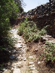
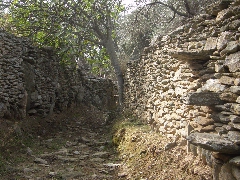
The green valley of Fléa. (0h41) After some 20 minutes you arrive at a junction where you take a right (note the blue dot and sign to Agios Nikólaos). But after 20 metres already you go left on a small gravel road, and very soon you find on the right the beginning of a beautiful trail between walls. The following 10-11 minutes are really marvellous, on an obvious and almost flat trail: at first it is sometimes nicely paved, later on it becomes sandy and runs between high walls, in the shadow of trees.
An unknown path between Fléa and Agia Marína.
A beautiful monopáti, with nice walls... After 11 minutes you get to a concrete road; you DO NOT go up to the right, but you continue straight ahead. (0h57) And then, all of a
sudden, after 5-6 minutes, the surrealistic and incredibly high tower of
Agia Marína rises in front of you!
The dilapidated tower of Agia Marína.
The tower and the little church of Agia Marína. At the cross-road, you DO NOT take the road on the left, alongside the church, NOR the middlemost road, but the road on the far right. In 2009 wooden signs were put here, and the trail was given the number [12].
The recent signs (2009) make this walk much easier! |
[You could make a detour of 3 minutes, going first straight to the source of Agia Marína: it is dated 1959 and you see many troughs and a large washing-place - this proves that this place once was very lively, which is not that surprising in this very fertile valley! You then return to the cross-road.]
(0h57) You thus take the dirt road to the right
- a few minutes later, you see on your
left another trail that leads to the source of Agia Marína (sign).
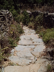
A nice threshing floor of alóni. (1h16) This is a great, natural trail with a wall on the left-hand side. The trail gradually descends with on your left a truly magnificent valley, the valley of Kremastí. The trail is sometimes beautifully paved, especially the second part.
The first part of the monopáti between Plagiá and Písses.
A nicely paved part of the monopáti between Plagiá and Písses.
The marvellous valley of Kremastí, towards Písses. You slowly veer to the right and the broad fertile valley of Pisses appears in front of you. A little later, the descent becomes steeper - there are steps, and the monopáti is sometimes covered with tall grass. You discover rather quickly the gravel road, down in the valley, where you will arrive. But you first turn right again, then left and so you come down in the valley.
The bay and the valley of Písses, a panoramic view from the asphalt road.
After a pleasant descent of
some 20-21 minutes, you get to a dirt and concrete road, that you follow towards
the middle of the valley [12], between high walls, and you finally arrive in the
river bed [12]. (2h01)
For the way back,
you follow exactly
the same route:
therefore you take the
dirt road next to the
palm trees of
Christóforos, you pass the
campsite and two
narrow roads,
and you go to the left
after 12 minutes -
there is a fig tree on
the corner, there is a
metal gate and a
mark [12]
on a wall.
Approximately 7 minutes
later, the small
road arrives between beautiful walls,
you continue on
the concrete road and you see
in a turn left two
paths in front of you -
you take the right one
[12].
The splendid pavement of the path. (2h46) After 25 beautiful minutes, a real treat, you get to the gravel road, next to some stables (2 X [12]). You go up on this road towards some houses, you pass above a beautiful alóni and you reach after 4 minutes the wider gravel road, where you take a right (the sign to the left indicates the direction of Psarópyrgos, and further there is a [12]). You need now 15 minutes to reach Agia Marína: gravel and concrete alternate and very soon you discover the tower in front of you. After 11-12 minutes, next to some houses, you keep to the right twice and so you reach the crossroads to the left of the tower. (3h06)
You continue on the
concrete road on the left of
the tower -
after 2-3 minutes, you pass
on your right the path that goes up
to Sklavonikóla,
following the walk
[12].
The nice path continues underneath high trees. After
4 minutes, you
keep to the right and the trail becomes
sandy -
you still see
the footprints that
you have left
with your shoes this morning! (3h44) You follow the narrow asphalt road for 4-5 minutes; at the moment that you have to the right a nice view on a large water mill, you have to pay attention: just above the chapel, there is a small gravel road that descends to the right. After another 10 meters, you continue on the staircase painted in white (sign and [2]).
A restored water mill...
The staircase and the sign, indicating the direction of Mylopótamos. The trail
arrives twice
next to the flowing
water, then
it goes down just next to
the first house (2
X [2]).
The last stretch of the path, just before arriving at Mylopótamos. Finally
you get to a gravel road,
next to a house
- you take a left
[2]. Almost
immediately the nice trail
[2] continues
to the right towards Ioulída,
but of course
you continue straight
in order to reach the main
road, where you left your car.
(4h05)
In
order to get the printer-friendly version
|
|


