2010, 2011, 2013, 2015, 2021
and 2023.
Walking, hiking and trekking on PAROS
WALKS
(last update on the 23rd of January 2023)
*** = very beautiful
**** = exceptional
+ Gpx = with Gpx-file
2. Léfkes - Agios Ioánnis Kaparós - Agios Geórgios - Aneratzá - Kamári - Alykí *** + Gpx
3. Léfkes - Kavouropótamos - Aspro Chorió *** + Gpx
4. Léfkes - Pígados - Panagía Thapsanoón - Parikiá *** + Gpx
5. Léfkes - Pródromos and back (the byzantine road) **** + Gpx
7. Parikiá - Panagía Thapsanoón - Agios Minás - Maráthi - Náoussa
8. Parikiá - Panagía Thapsanoón and back
Together
with Náxos the island of Páros takes a very particular place among
the Cyclades. After Náxos and Andros, it is the biggest island of the
Cyclades, just
before Tínos: its surface area is 195 km² and also its population is
quite large, namely about 10.000 inhabitants. Páros is situated fairly
centrally and therefore many boat connections stop there. Long distance
connections to Santoríni, to Kos and Ródos, to Ikaría and Sámos or to
Amorgós often stop in Páros, but also the line Thessaloníki - Iráklio (Crete)
for example calls in at Páros.
In
addition, there are a lot of connections with Sýros, Náxos, Ios
and many other Cycladic islands, especially due to the interesting
connections of the Aqua Jewel
and the Artemis, two
boats which are the successors of the old Panagía Tinoú and the Panagía
Chozoviótissa.
Finally, there are in Summer many supplementary (rapid) connections with Náxos, Mýkonos, Ios, etc.
In this way, travelers often
have to change at the island of Páros, for example to go from Amorgós to
Folégandros or Sífnos.
Boats leaving from
the Piraeus arrive at the harbour of Parikiá after 5 to 6 hours. Parikiá
is a thriving city, especially thanks to the busy harbour. It also has a
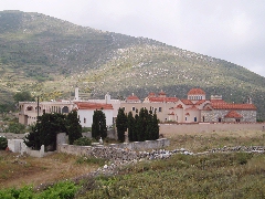
very attractive old city centre, with amongst others the famous church of
the Panagía Ekantondapilianí or Katapolianí (with the 100 doors) and with the beautiful
Kástro. From the harbour there are frequent bus connections with Náoussa,
with Léfkes via Maráthi, with Pródromos, Márpissa, Píso Livádi and
with Driós, Alikí, etc.
Náoussa
is the second biggest town of Páros and it has one of the most beautiful
fishing harbours on the Cyclades. From Náoussa you can get to the
beaches in the neighbourhood – possibly by taking a small boat.
Especially the beaches around Kolymbíthres are very pleasant.
Léfkes
is a really beautiful town, centrally located at about 15 km from Parikiá.
The houses are built in the shape of an amphitheatre around the church of
Agia Triáda.
Other places of interest are the old marble mines of Maráthi (on the road to Léfkes), the butterfly valley of Petaloúdes and of course the marvellous beaches: the beach of Kriós on the other side of the bay of Parikiá, the beaches around Náoussa with especially the beach of Kolymbíthres, the many beaches between Píso Livádi and Driós with the popular Golden Beach...
Also because the distances on Paros are greater than e.g.
on Sífnos, Folégandros or Amorgós, Paros is not that easy to walk, and
the real old paths are not that numerous either.
Nevertheless, there
are some very beautiful routes, such as of course the famous "Byzantine
road" and the kalderimi in the valley of the Kavouropótamos.
As always, the map in the Anavasi series is the best: on the 2018
edition the most special trails are marked, numbered 1 to 5. The best
center to start from is Léfkes, because that's where the trails [1],
[2], [3] and [4] start or end.
The path Parikiá - Moní Thapsanoón is not numbered and the coastal path
from Poúnta to Alykí is not shown on the map.
Since January the 1st 2004
you are visitor n°
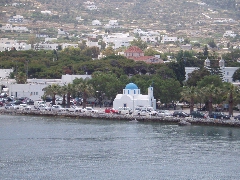
Panoramic view on the Katapolianí church in Parikiá
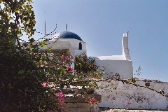
The church of Agios
Konstandínos on the Kástro in Parikiá
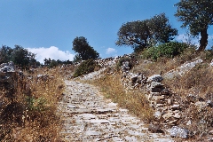
The beautiful "Byzantine
road" from Pródromos to Léfkes
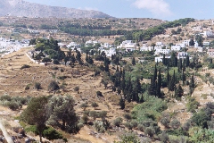
Léfkes
The monastery of the Panagía Thapsanoón