|
Káto Sagrí - temple of Démeter - Damariónas - Chalkí |
||
|
Evaluation:
This hike brings you
to the interior of Náxos, with as most important place of interest the temple of
Demeter. For the first part, to the temple, you follow a really nice trail, but
later on you only walk on gravel and asphalt. The hike gets an evaluation of **. Estimated time:
For the bus ride from
Chóra to Sagrí – the road taken by most of the buses going to Chalkí and Filóti
– you have to count on 40 minutes. After walking for 20 minutes you arrive in
Ano Sagrí, and then it will take you another 35 minutes to the temple of
Demeter. Some 40 minutes later you reach the impressive rocky hill of the Kástro.
For the long stretch to Damariónas, you should count on about 1h20, then you
need only 15 minutes to reach Chalkí – this brings you to an entire actual
walking time (AWT) of 3h10. We walked from 11am to 5pm – a total time of 6
hours, with a picnic break just beyond the side road to the Kástro.
Panoramic view on the valley of Potamiá with Agios Mámas. (0h00)
When getting off at the crossing to
Káto Sagrí you follow the
asphalt road for a few hundred metres, until you find a small concrete road on
the right – there is a signpost to Kanakári. This pretty lane meanders midst
broom and flowers (on the 20th of May 2004) and along the way you
notice that also in modern times Greeks like to build their houses in the style
of the former living towers. In the deserted village of Kanakári you keep to the
left and in this way you arrive at the larger asphalt road: straight across
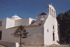
there is a church with the impressive name of Iera Mitrópolis Paronaxías
Evangelismós tis Theotókou – with a wonderfully shaded front garden. You go down a staircase
and a concrete slope, on the left of the church and then also on the left of the
ruins of a tower. Straight on you find a narrow path between walls – in front of
you, there is a mill and higher up you also see Ano Sagrí. You go down for a
couple of minutes and then you go up again on a nicely paved trail (which is not
on the map). After 5 minutes you get to the left of the mill; you continue on a
concrete road, past the first houses and you then walk on the meandering and
paved street, all the way through Ano Sagrí, in the same south/south-easterly
direction. You take a right, a left and then a right and a left again; at a
little square with a tree you go left once more. Further down you go right again
and – if you are lucky – you end up at the other side of the village, near the
restored monastery of Agios Elefthérios, with the monument for Xenákis just
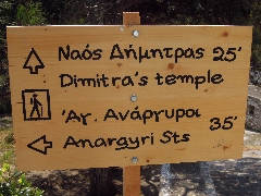
opposite. (0h20) In front of you, you see also a hiking sign to the "Naós Dímitras" + a red and white trail marker [7].
The hiking sign at the beginning of the trail to the temple of Demeter.
You descend the paved stairs to the right of the bust and you take immediately a
right onto a narrow concrete road – mind the red drawing of a temple on the wall
with an arrow to the right ...
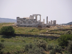
View on the site of the temple of Démeter.
(0h31) After yet another 6 minutes,
there is a small concrete road that goes down to the left, but again you should
continue straight on a narrow path on the right of a wall (large red mark).
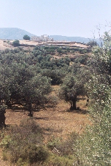
The nice monopáti towards the temple of Démeter. After about 5 minutes you arrive at a ruin and you see a path coming from the right. You proceed straight ahead (red dot), with a great view on the site of the temple of Demeter.
Panoramic view on the temple of Demeter. The trail has become stony and it goes down; after a little
while it becomes grassy again and past a stable you turn to the right, away from
the temple. Later on, on a swampy spot you go more to the left again -
fortunately. Further down there is another path coming from the right, and you
go straight ahead again. After some 48 minutes all together you reach the
asphalt road, which you have to follow to the left for another 6 minutes – you
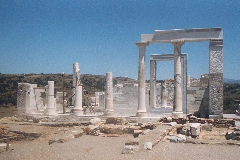
then get to the entrance of the temple of Demeter. (0h54) This site is nicely laid-out and a short walk first brings you to a small but interesting museum. The temple itself is nicely located, with a view on the gentle valley towards the south. It dates from the 6th century BC and in the 5th century AD it was converted into a church. Later on it was completely destroyed and many of the building elements were used for the construction of the chapel of Agios Ioánnis – and even for the construction of some farms. Only in the year 1949 the site of the temple attracted attention and after endless puzzling a part of the temple and of the Christian basilica were reconstructed – with a really nice result. |
The restored temple of Demeter. After your visit you
descend back to the asphalt road, where you continue to the left. (0h54)
After some 3 minutes
the asphalt comes to an end; when you reach a junction, you follow the gravel
road straight ahead. You go down, you go back up again and at the next junction
you take a right. Some 4-5 minutes later you go left, the gravel road turns into
concrete and after yet another 2-3 minutes it gets to the asphalt road. You take
a left, you walk past the turn to the chapel of Agios Geórgios (there is a
signpost) and after 6-7 minutes you clearly see two obvious signs pointing to
the right, to the Kástro Apalírou and to the "Vrýsi Adisárou" (The Well of
Adísaros).
Agios Ioánnis Theológos. You descend into the very
green valley, you go up again on a concrete slope and then the road becomes
gravel again. Some 8 minutes later you arrive at a junction and you take a right
(underneath an electricity cable). The road turns into concrete once more and
then you get to a steep climb – about 6 minutes later the road has become gravel
and you have to turn to the left sharply.
Another 3 minutes later, at
a very typical Greek chicken run with two Volkswagen wrecks, the
road turns sharply right - but
this time , you continue STRAIGHT , because you see already in front of you and
to the left a beautiful trail , with two large water pipes next to it .
The landscape during your walk to Damariónas.
After a rather steep climb of half an hour, you arrive more or less at the top.
Next to some Mediterranean maples, your road curves to the left - do not take
the small dirt road that continues straight, but continue to follow the main
road down.
The church of the Panagía in Chalkí. [If you have not yet paid
a visit to Chalkí, you should definitely have a look first: by taking the
shopping street leaving from O Giánnis you arrive close to the church Panagía i
Evangelístria i Protótronos. This church contains some beautiful wall paintings
and specially a marvellous ikonostási; unfortunately though, the church is
usually closed. On the left of the church you can walk into the small street to
have look at the large tower of the Pýrgos Grazía: also here you can notice the
coat of arms of the famous Venetian family Barozzi above the entrance.] You can find the bus stop
opposite the church. Usually, there is a bus to Chóra at about 20 to 5.
In
order to get the printer-friendly version |
|