2009 (2X), 2010, 2011, 2012,
2013, 2014, 2016, 2018,
2021, 2022, 2023, 2024
and 2025.
Walking, hiking and trekking on TINOS
MAPS
WALKS
(last update on the 22nd of January 2026)
*** = very beautiful
**** = exceptional
+ Gpx = with Gpx-file
1. Aetofoliá - Kalloní - Karkádos -
Aetofoliá
2. Aetofoliá - Plomári - Kolymbíthra ***
3. Agápi - Sklavochorió - Agápi
4. Agios Ioánnis Pórto - Agios Sóstis - Agios Fokás - Chóra
5. Agios Ioánnis Pórto - Dyó Choriá *** + Gpx
6. Agios Ioánnis Pórto - Dyó Chória - Stení - Falatádos ***
7.
Chóra - Agia Triáda - Triandáros - Dyó Choriá -
Arnádos - Kechrovoúni
***
8. Chóra -
Vaketa dam - Mountádos- Kechrovoúni - Arnádos
+ Gpx
9. Chóra - Kechrovoúni - Arnádos and
back **** + Gpx
10 Chóra - Kechrovoúni - Mountádos - Sberádos - Chóra ***
11. Chóra - Ktikádos - Kámbos - Tarampádos and back *** + Gpx
12. Chóra - Ktikádos - Kiónia - Chóra ***
+ Gpx
13. Chóra - Tripótamos - Xóbourgo - Falatádos - Voláx - Agápi ***
14. Chóra - Tripótamos - Xóbourgo - Koumáros - Loutrá - Kámbos - Chatzirádos - Ktikádos - Chóra ***
15. Chóra - Tripótamos - Xóbourgo - Koumáros - Voláx *** + Gpx
16. Dyó Choriá - Agia Faneroméni - Kounarés - Smóvolo - Agios Sóstis - Agios
Ioánnis Pórto *** + Gpx
17. Dyó Choriá - Arnádos -
Triandáros - Dyó Choriá *** + Gpx
18. Falatádos and surroundings ***
19. Falatádos - Koumáros - Skaládos - Voláx - Falatádos ***
20. Falatádos - Manganári and back **** + Gpx
21. Falatádos - Manganári - Myrsíni - Falatádos **** + Gpx
22. Falatádos - Manganári - beach of Liváda and back **** + Gpx
23. Falatádos - Myrsíni - Stení and back
24. Falatádos - Theosképasti - Voláx - Falatádos **** + Gpx
25. Falatádos - Xóbourgo - Koumáros - Loutrá - Krókos - Skaládos - Voláx - Falatádos ***
26. Falatádos - Xóbourgo - Tripótamos - Chóra
27. Kámbos - Agia Marína - Kardianí - Ystérnia - Pýrgos ***
28. Kámbos - Tarampádos and back
29. Kardianí - bay of Giannáki and back ***
30. Kardianí - Panagía Lakkotianí - Ystérnia
31. Kechrovoúni - Agia Marína - Agios Antónios - Arnádos - Kechrovoúni ***
32. Kechrovoúni - Mountádos - Sberádos - Tripótamos - Xóbourgo - Karyá - Tzádos - Kechrovoúni ***
33. Kechrovoúni - Tzádos - Kéchros - Stení - Dyó Choriá - Arnádos - Kechrovoúni ***
34. Liváda - Fáros and back ***
35. Loutrá - Xinára - Xóbourgo - Koumáros - Skaládos - Krókos - Loutrá **** + Gpx
36. Manganári - beach of Liváda and back *** + Gpx
37. Platiá - Karaboúsa - Agia Paraskeví - Róchari - Platiá **** + Gpx
38. Pýrgos - Marlás - Mamádos and back ***
39. Pýrgos - Pánormos and back *** + Gpx
40. Pýrgos - Pánormos - Kyrá Xéni - Pýrgos ***
41. Stení - Dyó Choriá - Triandáros -
Arnádos - Tzádos - Kéchros - Stení ****
42. Stení - Potamiá and back + Gpx
42. Stení - Potamiá - Maroúli - Lychnaftiá and back ***
43. Stení - Profítis Ilías - Tsikniás and back
44. Tarampádos - Smardátiko - Kómi - Plagiá - Agápi - Voláx ***
45. Tarampádos - Smardákito - Perástra - Krókos - Skaládos - Agápi - Voláx ***
46. Tarampádos - Smardákitos - Perástra - Loutrá - Kámbos - Chatzirádos - Ktikádos - Chóra ***
47. Tripótamos - Ktikádos - Chatzirádos - Kámbos - Loutrá - Xinára - Tripótamos ***
48. Voláx - Agápi - Kolymbíthra and back *** + Gpx
49. Ystérnia - bay of Ystérnia by the marble path and back **** + Gpx
50. Ystérnia - bay of Ystérnia by the stairs - Ystérnia by the marble path **** + Gpx
With its 195 km², Tínos is one of the medium-sized Cycladic islands,
after the two biggest ones: Náxos (448 km²) and Andros (385 km²); the
island of Páros (195 km²) has exactly the same size. Tínos is situated
between the isles of Andros and Mýkonos – together, these three islands
form the embranchment of the mountain ridge of the island of Evia (Euboia).
Just like its beautiful neighbour Andros, also the island of Tínos is
predominantly frequented by the Greeks themselves; it is not really a
busy tourist destination. Since the discovery of the miraculous statue
of Our Blessed Lady in 1823, Tínos has grown into one of the most
important religious places of pilgrimage of the Orthodox Greeks –
especially on the festival of Our Blessed Lady on the 15th of
August, the island and the area around the Panagía Evangelístria are
flooded with thousands of believers.
Nevertheless, Tínos
has to offer quite a lot, also to regular tourists: the interior of the
island is absolutely wonderful, it is fairly green and there are a lot
of small villages; there are many chapels, skilfully decorated pigeon
towers, beautiful beaches and also the marvellous hiking trails.
Tínos is situated on
the busy shipping route to Mýkonos: it is to be reached easily from the
harbour of Rafína (there is a special bus to Rafína from the airport!).
After about 2 hours of sailing the boat stops in Gávrio on the island of
Andros, and after 4 hours you arrive at Tínos. But also from the
Piraeus, the main port of Athens, there are a number of connections
every day: the Highspeed-boats and also modern ships such as the Blue
Star Ithaki take care of some fast connections via Sýros and Tínos to
Mýkonos – in this case the crossing to Tínos takes about three hours and
a half. In summer, there is also a direct connection with the island of
Páros, the central island of the Cyclades (by the Seajet 2).
You often have to pass the isle of Páros or Sýros, in order to continue
to the other Cyclades: the Aqua Jewel, Aqua Spirit and Artemis
(successors of the small Panagía Chozoviótissa and the Panagía Tínou)
take care of connections with Sérifos, Sífnos, Mílos and Kímolos or with
Kýthnos, Kéa and Laúvrio; they even bring you to the islands of Síkinos,
Folégandros, Santoríni and Anáfi and this throughout the year.
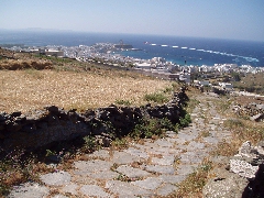
The capital of Tínos, called Tínos or Chóra, is
pleasant little town. It is dominated by the large building of the
Panagía Evangelístria; the one-kilometre-long boulevard of Megalocharis
leads to this church. On the side of this road there is a strip of
carpet for pilgrims who want to undertake the trip to the church on
their knees. The interior of the church is remarkable because of the
large number of ex votoes, often also small silver ships. The new
harbour is located a little on the side of the centre and it does not
offer you anything in particular; the old harbour promenade is quite
nice and, as often, it is flanked by restaurants, shops and bars.
In the interior
there are the villages such as Voláx, Koumáros, Krókos,
Kómi, Ktikádos, Agápi, Tarampádos,
Falatádos,Triantáros, etc (in the centre of the island),
Kardianí, Istérnia or Pýrgos
(towards the north) and many more, which are very picturesque and
attractive to stroll around. It is almost unbelievable, but there are 60
villages dispersed all over the interior of the island!
Some of them, like
Koumáros and Agápi, are quite striking because of the arched passages (kamáres),
others, such as Tarampádos, are remarkable because of the large number
of very skilfully decorated pigeon houses. In the neighbourhood of
Falatádos and Myrsíni you will be struck by the very special landscape
with a lot of large boulders.
The plateau of
Xóbourgo
(with the old fortress, at an altitude of 559 metres) and the highly
situated monastery of Kechrovoúni (near the village of Stení)
give you some exceptional panoramic views over the island. Between Chóra
and the bay of Kiónia you
can find the remnants of the temple of Poseídoon and Amfitríte.
Besides the beach of Kiónia and the one of Kolimbýthra (on the north coast), it is mainly the beaches situated on the wind protected south-east coast, around Pórto, that are very pleasant, such as the beaches of Agios Fokás, Agios Ioánnis or Agios Sóstis.
Just like many other
Cycladic isles, also Tínos is best to be explored on foot. Tínos
contains a wealth of marvellous hiking trails, especially in the centre
of the island and in the southeast, but also around Kardianí and Pýrgos.
Some parts of the ancient kalderímia are remarkably well preserved – for
instance the stretch between Chóra and Ktikádos is incredibly intact.
In spring 2008 a
nice
map of Tínos was published in the Anávasi-series. The actual
map (scale: 1/25 000) presents a whole lot of hiking trails, while at
the backside an entire network of trails is explained – with no less
than 25 hiking trajectories. The combinations of trails are almost as
numerous as on the island of Sífnos. Because Tínos is a fairly large
island, the total length of the trails is probably more than 200 km!
In the course of spring 2009 another map of Tinos appeared, now in the series of Terrain Maps: this map is also very detailed but a little less clear than the Anávasi-map.
In addition, on the island of Tínos, just like on Amorgós and especially on Andros, on Sífnos and on Kéa, a great effort is put in the signposting of the hikes nowadays.
On the initiative of the municipality of Tínos (Dimos Tinou), a network of 150 km of trails has been created and marked, see the very interesting site https://www.tinostrails.gr/
We want to mention hree other
very interesting websites:
- the website with walks by
Karolos Merlin
- http://www.tinos-cyclades.com:
interesting site (in French) by Christian FETIS, who lives on Tínos
since 1987
- the blogspot http://imaginarytinos.blogspot.com
with marvelous photos of Tínos.
Just like on Amorgós
and Andros, there also exists a little, but beautiful book, published by
the cultural organisation Archipélagos, with a brief description of 10
hikes - in Greek, English and French – to be found in the shops in Chóra.
The descriptions of the hikes are not really route descriptions, but
they can give you an impression of some of the hiking possibilities.
Finally, also the Greek guide "Kykládes", published by Explorer, pays
quite a bit of attention to the hikes when discussing the island of
Tínos. Also here the information is too limited, and in the English
translation of this guide this section was even left out.
Since January the 1st 2004
you are visitor n°
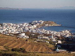
Panoramic view on Chóra
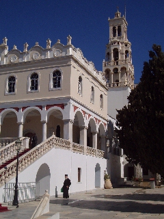
The Panagía
Evangelístria
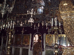
The rich interior of the Panagía Evangelístria
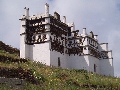
The decorated pigeons of Tarampádos
The splendid old monopáti that leads from Chóra to Kámbos

The hill top of Xóbourgo
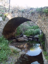
The Venetian bridge near Ktikádos
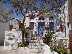
The picturesque village of Voláx
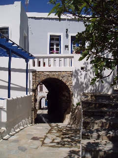
The arched passages in Koumáros