2015, 2016, 2018, 2023
and 2024
Walking, hiking and trekking in Zagóri
HIKES
(last update on December the 18th, 2024)
*** = very beautiful
**** = exceptional
1. Astráka refuge -
Drakólimni and back ****
2. Avgerinós - Mégas Lákkos - bed of the Veránia and back **** + Gpx
3. Bridge of Arísti - Agii Anárgyri - Bridge of Klidoniá and back **** + Gpx
4. Kapésovo - Gradísta - Iero Dásos - Víkos gorge - Kapésovo ****
5. Kapésovo - Koukoúli and back
6. Kapésovo - Víkos gorge and back
7. Kapésovo - Vradéto - Belóï and back **** + Gpx
8. Kípi - Bayótikos - Mísios
- Vítsa and back
***
9. Kípi - Kapéssovo and back ***
+ Gpx
10. Kípi - Lazarídis - Koukoúli - Mísios - Vítsa - Monodéndri
**** + Gpx
12. Klidoniá - Ano Klidoniá and back
13. Megálo Pápingo - Ano Klidoniá and back **** + Gpx
14. Megálo Pápingo - Koúla - Ano Klidoniá - Megálo Pápingo ***
15. Mikró Pápingo - Astráka refuge and back **** + Gpx
16. Mikró Pápingo - Kókkino Lithári - Evangelístria and back **** + Gpx
17. Mikró Pápingo - Megálo Pápingo - (Ovíres) - Mikró Pápingo + Gpx
18. Mikró Pápingo - source of the Voïdomátis and back **** + Gpx
19. Mísios - skála Monodéndri and back
20. Monodéndri - Agia Paraskeví and back + Gpx
21. Monodéndri - Ano Pediná and back + Gpx
22. Monodéndri -Stone
Forest - Oxyá and back **** + Gpx
23. Monodéndri - Víkos gorge - Víkos ****
24. Monodéndri - Vítsa - Mísios - Koukoúli - Kípi ***
25. Swimming in Zagóri ***
26. The three bridges hike ****
+ Gpx
27. The four bridges hike ****
+ Gpx
28. The five bridges hike **** + Gpx
29. Tsepélovo - Mégas Lákkos and back ****
30. Tsepélovo - Chátsios - Paliogéfyro - Tría Kefália - Kípi and back
31. Tsepélovo - Trýpa Nýfis - Kapésovo and back ****
32. Tsepélovo - Vradéto - Kapésovo ****
33. Víkos- source of the Voïdomátis and back **** + Gpx
34. Víkos - Víkos gorge - Monodéndri ****
Zagóri is part of the Greek
region (periféria) Ipiros, which is one of the 13 Greek regions; Ipiros is
located in the north-west, between the Ionian Sea and the Albanian border.
It is also the most mountainous region of Greece: the Píndos massif,
considered as the backbone of Greece, spreads from north to south over a
distance of 160 km, with peaks as the Smólikas (2637 m), the Týmfi (2466 m
), the Gamilá (2480 m) and the Astráka (2432 m).
The area of Zagóri is 1000 km²: the region lies more or less north of the
city of Ioánnina, the capital of the largest province (nomós) of Ipiros. Administratively, Zagóri
forms a single municipality (dímos), but it counts no less than 46 small
villages, the so-called Zagorochoriá (chorió = village) or Zagoriá. However,
the total population does not even reaches 4000 inhabitants, which
corresponds to a density of less than 4 per km².
The name
Zagóri is probably Slavonic and could mean "beyond the mountains".
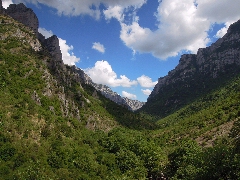
This mountainous region is not easily accessible and is also crossed by some
very deep valleys, with rivers like the Vikos, with its tributaries Vikákis
and Mégas Lákkos, and the Voidomátis and the Aoös. During millions of years
the Vikos has carved the canyon of Vikos, which is about 20 kilometers long
and has a depth of 450 to 1600 meters; the canyon of Vikos thus appears in
the Guinness Book of Records as the deepest canyon in the world - taking
into account that the canyon has the greatest depth / width ratio, because
the canyon is very narrow in some places.
Because of these geographical features, the history of this region of Greece
is just as remarkable. While large parts of Greece have had a turbulent
history, the region of Zagóri has been living
in relative safety during centuries,
largely due to its difficult accessibility - invasions often avoided the
region. Even when Ipiros fell into the hands of the Turks, in 1430, the
region retained considerable autonomy. Many merchants came to live there,
which contributed to a relative prosperity: many schools have emerged in the
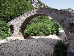
18th century, a lot of bridges and
water mills were built, and the “archontiká" or large luxurious stone houses
also testify to this prosperous period. It was only in the 19th century that
the Turkish occupation became more
severe – until finally Zagóri was liberated from the Turkish occupation
during the first Balkan War in 1913.
After the reunification with Greece, the region experienced a long exodus to
the cities of Greece and a steady depopulation. It also suffered heavily
during World War II , first as a result of the
Italian invasion, then of the German occupation, and finally of the civil
war. All this has meant that the region of Zagóri remained cut off from the
world: it thus retained its original
character - this explains the presence of very traditional villages and a
well maintained trail and bridge network.
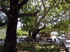
Most of these villages are very typical, with their central square or platía,
with a large church, a huge plane tree and a public fountain; winding alleys
cross the villages and a network of trails or monopátia connect the villages
- with here and there the famous arched bridges. The most famous villages
are Monodéndri (with Vítsa close to it), Tsepélovo (the largest village),
Vradéto (the highest village, 1340 m) and the very attractive villages of
Kípi , Koukoúli and Dílofo; north of the Vikos canyon you can find
the very famous villages of Megálo
and Mikró Pápingo, the villages of Vikos, Arísti , etc.
For the most beautiful villages of Zagóri, see e.g.
http://www.zagori.info/
or
http://www.about-ioannina.gr/Zagori_en/Zagori.htm
These trails lend themselves to hikes of one day, but also to trekkings of 6-8 days, which are organized by many travel agencies. One of the most famous trekkings starts in Tsepélovo, taking the following steps: Tsepélovo - Vradéto - Kapésovo / Kapésovo - Koukoúli - Kípi / Kípi - Dílofo - Vítsa- Monodéndri / Monodéndri - canyon of Víkos - village of Víkos / Vikos - Megálo and Mikró Pápingo / and a stage of two days from Pápingo to the Astráka refuge and the Drakólimni lake - sometimes this trek is closed by a solitary stage back to Tsepélovo.
In the series of walking guides from CICERONE (www.Cicerone.co.uk) a handy walking book was published in 2019 by Aris Leontaritis. This hiking guide "Walking and trekking in Zagori" offers 30 walking tours and 3 multi-day treks in the national park of the northern Pindos, of which 20 in central Zagóri, the region that is also covered in this site. A very nice book, with sections on history, geology, fauna and flora, beautiful photos, precise maps and especially clear descriptions of the hikes!
For some nice walks in and around Pápingo, there is the charming booklet Exploring Pápingo, by Frances Annear.
As so often, the best map is the one of Anávasi: the map 3.1 for Zagóri is a very good map with a scale 1: 50.000 - it represents all of the major trails and is very accurate.
Some important practical information
See the information on the website of KTEL (bus) Ioannina,
http://www.ktelioannina.gr/TRANSPORT7/PAGE_Routes/ZB4AAI8lw0BhZGpGbHJydVREDQA
(only in Greek).
In summer 2014, you could find the following connections:
- Ioánnina - Pápingo: only on Tuesdays at 5.30 am,
return at 7.00am + (if there are travelers!) at 2.30pm, return at 4.00 pm
- Ioánnina - Vítsa – Monodéndri - Ano Pediná - Elafótopos: at 5.45am on
Monday, return at 6.30am
+ at 2.00pm with return at 3.15pm
- Ioánnina - Skamnéli: at 6.00am and 1.35pm on Friday (by Koukoúli), return
via Kapésovo and Koukoúli at 6.55am and direct return at 3.15pm
- Ioánnina - Frangádes - Leptokaryá: Thursday at 5.15 am, return at 3.15pm
- Leptokaryá - Frangádes - Dilofo - Ioánnina: Thursday at 6.45 am, return at
3.45pm (by Dilofo only if there are travelers!).
Conclusion: Given the fact that the connections are only once
a week and at difficult times, it is unlikely that the bus will help you to
establish a good
walking
program...
There are a
few taxis in the region for several years already;
some numbers are: + 30 6944 33 54 87 (Monodendri) or + 30 26550 22500 (Kónitsa).
However, it is easier to rent a car...
* Service stations are also rare:
you will
find
no service station at all in Zagóri itself! There is one (coming from Ioánnina)
on the road
from
Metamórfosi to Monodéndri and another (coming from Kónitsa)
in Klidoniá. You should therefore take
your
precautions ...
* The same foresight is necessary for
cash: there are
very few
teller machines (ATM) in Zagóri
- there is since 2017 one in Monodéndri and one in Megálo Pápingo. Since
many hostels and even hotels do not accept bank cards, you should provide
with cash!
* The nearest pharmacy is
in
Metamórfosi
* You easily will find accommodation
with the help of the Internet
-
see
also
the links on this site. Good centers for excursions are especially Tsepélovo
and Mikró Pápingo, but also Kípi, Monodéndri, Vítsa and Megálo Pápingo are
suitable
* Even in summer (July), not all
taverns and restaurants are open, especially on weekdays. We found
restaurants in Tsepélovo, Kípi, Dílofo, Vítsa and Monodéndri in central
Zagóri, and in Mikró and Megálo Pápingo,
in Ano Klidoniá
and Víkos
*
a nice website for a small guest house and guided treks:
www.lucas-adventures.com
.
Since Januari the 1st 2004
you are visitor n°
The skála Vradétou
UUView
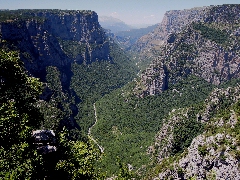
on the Víkos gorge, from the viewpoint of Belóï
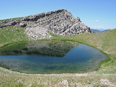
The Drakólimni
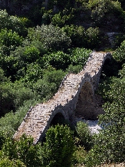
The Plakída
bridge, with the three arches

The
reflection of the Lazarídis bridge near Kípi

The platía
of Tsepélovo
The Mísios bridge
00The platía in Víkos
The Víkos gorge near Víkos