2015 and 2019
Walking on METHANA
WALKS
(last update on November 15th, 2019)
*** = very nice
**** = exceptionnal
NNN = new in 2019
3. Walk [2]: Kypséli - Stavrólongos - Agios Athanásios - Profítis Ilías and back
6. Walk [4]: Megalochóri - Panagítsa - crater of Makrýlongos - Profítis Ilías and back ***
7. Walk [4b]: Megalochóri - Panagítsa - Makrýlongos - Megalochóri
12. Walk [6]: Vathý - Megalochóri and back
13. Walk [7]: Vathý - Megalopotámi and back
14. Walk [8]: Kaïméni Chóra - volcano and back
15. Walk [9]: Megalochóri - Acrópolis - Agios Nikólaos - Profítis Ilías - Almýra
16. Walk [10]: Kypséli - Oga and back
17. Walk [11]: volcano - Makrýlongos - Paleá Loutrá - Agios Nikólaos + Gpx
18. Walk [12]: volcano - Cro - Paleá Loutrá + Gpx
19. Walk [13]: Paleá Loutrá - Cro - volcano - Makrýlongos - Paleá Loutrá - Agio Nikólaos *** + Gpx
Méthana
is a small peninsula
on the north-east coast of the Peloponnese;
this area measures
50.16 km²
and it had some
1150 inhabitants in 2001.
The peninsula is only
connected to the mainland by
a narrow isthmus.
Méthana is part of
the municipality of Trizinía,
of which Galatás is the main city, located on
the Peloponnesian coast opposite
the island of Póros.
Geologically speaking, Méthana
is a very interesting region: a
long time ago, it was very volcanic and
nowadays, it counts no
less than 32 ancient
craters. One can also see some
ancient lava flows, but it is
the volcano located in the north-west,
not far from the village of Kaïméni
Chóra (=
burned village), that is the most spectacular
witness of this volcanic
past – over here, one can really imagine
oneself in a true
landscape of volcanoes.
The last eruption happened
in the year 230
BC: a
volcanic flow of more than one
kilometer
shifted
the coast
over a length of 500 meters.
Writers such as Pausanias,
Strabo and Ovid
testified about it
in their writings.
The Méthana
volcano is located on
the volcanic arc
that crosses the Aegean Sea and
on which also the islands of
Mílos, Santoríni and
Nísyros are situated.
For more details on the
Méthana Volcano,
see
http://www.volcano.si.edu/volcano.cfm?vn=212020 and
http://www.volcanodiscovery.com/methana_saronic_gulf/methana_volcanoes.html
Hot springs can be seen in many
places and the city of
Méthana still has sulfur
baths
which
are said
to possess beneficial qualities
against rheumatism
and skin diseases.
The peninsula
is very mountainous, with the Chelóna as the
highest peak – it measures 740
meters. Another mountain range of
3 km
is located in the
northwestern part of the
peninsula.
The history of Méthana
experienced the same turbulence
as the rest of the
Peloponnese region: there was,
for example, a golden age
in the Mycenaean period
- the
Paleókastro, an acropolis built between 1500 and 1300
BC, can still be seen near the small village of
Vathý.
During the Peloponnesian War
(431 -
404 BC)
the Athenians
built a long wall
to cut the peninsula off
from the main land, an
accomplishment
described
by the historian
Thycidides.
During the Hellenistic period,
after the reign of Alexander the
Great, Méthana
fell under the rule
of the Ptolemaei, the kings of
Egypt: the peninsula
was then given the name of
Arsínoë (that
was also the name of the
daughter
or
the sister of
various kings of the
Ptolemaic dynasty).
The small capital of the
peninsula bears the same name:
Méthana;
there is a
small harbor, a pretty
nice promenade and
quite well known medicinal baths,
located in a large
neo-classical building.
The village of
Vathý also
has a small marina, a
favorite anchorage for many
sailors.
A number of other villages are noteworthy, such as the
villages of Megalochóri,
Megalopotámi,
Kaïméni
Chóra or
Makrýlongos
- they are 13 in total.
Because of its relative isolation,
the peninsula is not very
touristic, although it takes only 2h30 by
road from Athens and 2 hours
by sea from the Piraeus.
If you want to go
by car, you should first follow
the highway E94 from
Athens; after passing the Isthmus
of Corinth one follows
the winding but very scenic
road that follows the coastline of the
Saronic Gulf and passes
not far from Epídavros.
By sea, there are
quite frequent connections with
the port of Piraeus and
the islands of Aegina,
Póros and Hýdra - see
www.gtp.gr
There are almost no detailed maps
of the area – there is
only the geological map
of the Swiss "Institute for
Cartography", carried out with the help of
Tobias Schorr,
but it dates back from the years
1991-1994, so from before the
construction of the new road
from Kaïméni Chóra to Makrýlongos
and Kypséli. Although this
map is difficult
to find, it is this map I used to make an
adapted version with
the new road and the walks
- see on this page to the left.
The Méthana
region can offer you
a lot of
hiking options.
About ten years
ago some of
these trails were marked with
wooden hiking signs and
colored symbols. Nowadays,
these symbols are often only half visible
and some trails
have become impassable
because of the vegetation.
At the initiative of some
residents, one started to clear
some of the paths, sometimes with
the help of Belgian scouts:
for instance, in summer 2011 they cleared the
path from Megalochóri to
Panagítsa. In the summer of
2012 they worked
in the area of the small
Profítis Ilías and during the
summer of 2013 they cleared
the path that leads from
Megalopotámi to the
chapel of Agios Ioánnis.
In July 2014,
a few other sections were also
cleared.
This site aims to contribute to
the discovery of these walks.
The final goal is to reconstruct
a network of trails, in
which the most important
paths (numbered from [1]
to [9]) intersect in
a knot that was once located
on the trajectory of the roads to
Kaiméni Chóra, the village
of Makrýlongos
(or Apáno Moúska)
and Kypséli.
But now, I consider this knot to be situated at the foot of the
Profítis Ilías - this allows
you to change to another walk at exactly that spot
and thus follow an itinerary
on measure.
But you can also make
the most important walks back and forth,
with starting points
in Méthana, Kypséli,
Thróni (near
Dritséïka) Megalopotámi
or Megalochóri.
The trajectory of the trails
was disrupted in the years
2003-2005 due to
the construction of the paved
road from Kaïméni Chóra to
Makrýlongos and
Kypséli; this road
almost destroyed the gravel road
or the trails over a distance of
about 5 km.
To join the itineraries of these
walks, it is unfortunately necessary to
follow this road for
some distance. So if you want,
for example, to continue the walk
[1] that comes from
Méthana to the Profítis
Ilías, you should follow the
paved road over a distance of
500 meters;
walks [2] from
Kypséli and
[3b] from Dritséïka
also follow the road
for some time...
The ultimate goal is to clear
as many paths
as possible, and realize a
true trail network
that allows the walker to
follow all walks
without long stretches on
the asphalt road.
For the moment, five
hikes
back
and forth are available,
with starting points
in Méthana, Kypséli,
Dritséïka, Megalochóri
and Megalopotámi, each
time until the Profítis Ilías
- they are numbered from
[1] to [5],
with some variants
[1b], [3b],
[4b] and [5b].
In addition, there are two
beautiful circular walks,
combinations of walks [5] and
[4] and walks
[3] and [5].
There are
also
a few smaller walks, numbered from
[6] to [10]: there is
of course the short walk
to the volcano, but also two
short trips that leave from
Vathý and allow you
to start the other
hikes down at the coast.
Finally,
there are three walks in the region between the volcano and the villages of
Makrýlongos and Paleá Loutrá: they have been cleared in 2019 by a group of
volonteers around Elias Rizos and got on this site the numbers [11], [12]
and [13].
Since January the 1st 2004
you are visitor n°

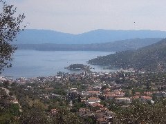
General view of the peninsula of Méthana
Panoramic
view on the city of Méthana
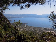
Panoramic
view on the Saronic Gulf
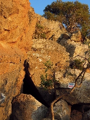
On the volcano...
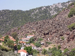
Kaïméni Chóra, almost covered by a lava flow
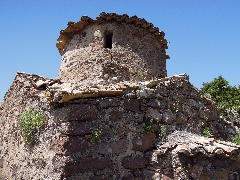
The old little church of Panagítsa
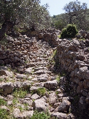
The monopáti from Megalochóri to Panagítsa